Showing posts with label hot spring. Show all posts

Monday, May 2, 2011

Horn-billing


Phetchabun province is just over 4 hours easy drive from Bangkok, but it's a great place to visit which (despite it's proximity) still receives next to no tourist; even Lonely Planet doesn't mention this beautiful province!

In essence, Phetchabun province is a wide north-south valley, crammed between at first hills, later on 1000+ m, so no wonder that waterfalls are a major feature, though surprisingly scarcely visited.

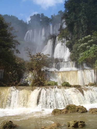
One of the lesser known national parks in Phetchabun is that of Tat Mok, considering that the province also contains the Hin Rong Kla national park. The 290 square km Tat Mok National Park is named after it's signature waterfall which is said to be a 1-level 200-300m high waterfall

Getting here is not too difficult, from Phetchabun town head southeast and take road no. 2271 until it reaches road 2275. A right turn is required and then quite quickly the entrance to the park will need a left turn. From the entrance it is 18 km over a mountainous road to the road head.

Not many foreigners make it this far up-country and after the ticket lady contains her surprise thereafter followed a frantic scram (involving 4 staff members) to find the correct 200B entrance tickets, nearly 7 $US (April 2011).


It takes about half an hour to drive the deserted road to it's ultimate destination. Going up there are two larger viewpoints, if clear one could easily see Phetchabun town. After the first hill there are some more offices and a campground, beyond seems to receive even less visitors. At a certain moment I need to get out and remove a large branch from the otherwise good road. The valley gets more narrower and ends at a small car park with some amenities, but no one seems to be hanging around on a late Monday afternoon.

The track then starts and should last for nearly 3 km, 45 minutes. It's not often that in Thailand there are long walks possible (Thai's prefer drive-in nature) and certainly not well signposted ones. The trail hugs either side of the stream and has seen better times. On narrower sections, the improved pathway has been washed away as do all bridges. Attempts have been made to keep the track passable and it really is a nice beautiful walk.

An improvised bridge

Finally one comes to a section where the trail splits, the lower path continues onward for another 200m to the Song Nang waterfall (or Songnang)whereas the higher steps should take you to Tat Mok.

As rain is threatening with clear intentions of today's daylight being curtailed, I skip the Tat Mok part, as it is a high waterfall but with little water.

Instead the Song Nang waterfall is in front of me. It's a 10 level waterfall with delicious pools to skin dip in, yeah!


Author chillin

After chilling out it's time to return, drops of rain are falling. The best part of this is that birdlife are welcoming the moist and are out in numbers, audible though not visible. A salvo of larger cries leads me to believe that horn-bills are overhead and low and behold at an opening I see no less than 10 juveniles frolicking in the tree tops.

Back at the end of the road, there is still a great place to rinse off the return sweat before returning to civilization.


There are a couple of web sites on Tat Mok, mostly poorly translated from Thai, resulting in a load of gibberish, see for instance
'Tat Mok - two waterfalls her'.
sbayura.com has a good posting on Tat Mok / Song Nang including extensive photo's.
Thaiways has a picture of level 6.

Nearby is the hot spring of Nam Rong, possible as a post walk soak.

Monday, April 4, 2011

Past the bear pit


Part of the Yang Bay Tourist Park complex or at least just outside the most developed part of this tourist development complex, Ho Cho waterfall is a wide low waterfall, in all descending 6-8 m. I guess. Below is a great pool where one can take a very undisturbed swim. At least during the week, when visitors are few and far between.

That's for now. It's quite strange, this lack of even a decent track, slam-bam next to Yang Bay Tourist Park. Instead of going to Yang Bay waterfall itself, once inside the 'park' one takes the left road past the bear pit, tribal game place and orchid garden. Abruptly the wide road stops (10 minutes after taking the road) at a wild stream.

A small path continues through the high grass to the river where a small log has been laid over the first 2 m of the river crossing; the rest can be achieved by jumping from rock to rock. On the other bank of the river, the track continues through the forest until it hits the rock-face of the waterfall itself. No track beyond this by the look of it. Time for a dip.


The Yang Bay Tourist Park companies brochure describes Ho Cho as follows:
‘To be deep in the forest. Ho-Cho waterfall is considered as a challenge to visitors. Ho-Cho waterfall also owns a lot of hot mineral water sources helpful for cure’.
Well, the effort required can not be described as a challenge, it is pretty easy. I'm unsure about the hot spring claim though, it certainly was not apparent.

Another link to the possibility of there being mineral water is here:
'After a refreshing dip, visitors can relax in a natural hot spring'.
As stated in the Waterfalls of Southeast Asia blog entry on Yang Bay, management may want to expand the mineral water on offer and add in some mud (as in the success of Thap Ba hot spring).

It's a pity that not much is made of the current mineral water facilities, if existing.

Despite the development, Yang bay and certainly Ho Cho are worth the effort.

Update [June 2012]
This article mentions 
'The waterfall [Ho Cho] includes two streams, one hot and one cold. If tourists fancy having fun in the hot water or just want to relax, the park management board has built a swimming pool, which mixes the two streams of hot and cold water.
The waterfall will soon be developed into a hot spring site'.
All part of an expansion ...

Wednesday, October 20, 2010

No sunny rainbow


Umphang district is synonymous with waterfall fame, at least in Thailand. Literally located at the end of one of Southeast Asia's most twisting and winding roads (just over 1200 curve's until the next district of Mae Sot) national tourists flock here, not to experience the torturous road, but to visit Thi Lo Su, claimed to be Thailand's 'largest' waterfall (height 200m, breadth 400m, see blog entry on Waterfalls of Thailand). Wikitravel adds that it's among the worlds six most beautiful waterfalls.

As apparently the final 40 km of road from Umphang village to the waterfalls are closed during the rainy season (visit took place early October 2010) visiting the waterfalls is not a lightly undertaken mission, an offer my son was not willing to give.

Heading into the wild.

So we opted for second best, rafting down Mae Klong river (which is another reason Thai tourist flock to here outside of the rainy season). Though Thi Lo Sur wouldn't be on the cards, a delightful hot spring (see Soaking in Siam) and the undisturbed wilderness would. And there's the sensation of floating on the raft below a waterfall, the waterfall called Thi Lo Jau (Thi Lo Cho or Saifon) Both translate (from Karen and Thai) as rainbow.
Apparently once the sun shines early morning you can see a rainbow. Despite this info and the urgency to get there early, the sun wasn't shining so no neat pictures of the rainbow. But no need to worry internet guarantees that somewhere there is the picture perfect of the waterfall and rainbow in one.

Because of the remoteness of Thi Lo Jau, boat is the only option in getting here and the only option in experiencing the falls as it is located in a canyon like setting: both banks of the river are steep rocks. Boats / rafts leave from just outside of Umphang village and in season combine a visit to Thi Lo Su, while out of season one needs to walk (3-4 hours) and add an overnight stay. In the rainy season though, after a total of 5 hours, you and the raft are brought back the 25+ kms to Umphang.

World of waterfalls has beaten me to posting this on their blog, much better photo's too.

Another similar fall.

There are more waterfalls along the way, some bigger some smaller. This one (see photo's below) on a side river has it's own name, Mor something.


Elsewhere in and around Umphang, besides the two waterfalls above there are the waterfalls of Le Tong Khu,
Thi Lo Rae, Sepla (Se Pla or Ze Pala) and even Thi Cha Na Ta.

Thursday, August 12, 2010

Over-looked?


Sometimes there are waterfalls right in the middle of a heavily touristed area where nobody seems to come. Batu district, already characterized as 'Small Switzerland' by the Dutch, sees many national tourists, none seemingly missing out the chance to visit Selecta's swimming pool.

But only a km or 2 upstream from this Dutch era swimming pool is the waterfall of Air Terjun Coban Talun. Getting here involves continuing up the mountain for about 2 km (following the main road) and then taking a well-signposted left for another 1,5 km. There is a small ticket office which doesn’t seem to be at all attached to the falls themselves, but it's simply the end of the road. Entrance fee is something like 3,100 INR (~3,50$US).

View along the way, after crossing the river. Far away one can see the town of Batu.

The track starts again off to your left and you gradually descend to the river level, above the falls. Here the track goes through the river and continues on the opposite bank. For another 750m the track hugs the mountain side as the valley drops away. Then a steep descent and after a total walk of 30 minutes one is at the foot of the 50m+ high falls.


Underneath (and probably above) the quite clean surrounded waterfall are some nice pools to cool off in. Do note that the climate here is already a lot cooler ... The lack of refuse may well indicate that there was lack of visitors ...., all the better for others to enjoy!

Nearby are other attractions such as a cave used during the Japanese occupation. This according to eastjava.com.

In the Batu region other significant natural attractions are Cangar hot springs (about 8 km up road) as well as further away the hot springs in Songgoriti and Cubanrondo waterfall. Coban Rais is another local waterfall.

Wednesday, December 9, 2009

Thailand's Best?

Ti Lo Su, Umphang, Tak province. By spannar00oi

The Thai language Places and Prices coffee table magazine published an issue 2 years back with top Thailand destinations. These were their choice of best waterfalls, without ranking:
  • Klong Thom Ron waterfall (being a waterfall as well), Krabi, Southern Thailand
  • Huai Khamin waterfall, Kanchanaburi, Central Thailand
  • Thi Lo Su, Tak, Northern Thailand
  • Thi Lo Re, Tak, Northern Thailand
  • Khlong Lan, Kampaeng Phet, Central Thailand
  • Tat Mok, Phetchabun, Central Thailand
  • Saeng Chan, Ubon Ratchathani, North-Eastern Thailand
Saeng Chan waterfall makes the list because it goes through a hole in the rock. Photo source.
  • Mae Surin, Mae Hong Son, Northern Thailand
  • Heo Narok, Nakhon Nayak, Central Thailand
  • Phraiwan, Phattalung, Southern Thailand
  • Krung Ching, Nakhon Si Thammarat, Southern Thailand
  • Ton Nga Chang, Songkhla, Southern Thailand
  • Mae Ya, Chiang Mai, Northern Thailand
There are probably many more that could of made the list. It's not mine. They may have tried to include all regions and be politically correct ....

Thursday, November 19, 2009

Forgot, not


In my haste to put as much as possible of the waterfalls I have visited in Southeast Asia, a couple have fallen off the track so it seems. One which seems very unique is the waterfall of Angseri, Bali, Indonesia. Where else can you shower under a 7-8 m high waterfall after which you can take a hot soak at an adjacent hot spring? Well, maybe not so unique, but something special.

I have an extensive posting on the hot spring on my Soaking in Southeast Asia blog which seems to sum up most.

Another waterfall is a large waterfall that flows in the Telega Waja river, Bali, Indonesia. As I was rafting at the moment no photo's. Let's download
someone else's:

It's quite high and too powerful to be underneath. Name:?

Monday, November 9, 2009

More unknown

Located along the old road to Bentong (of the unremarkable hot springs fame) even the best website in Southeast Asia on waterfalls mentions this as 'unknown':
'This nice unnamed waterfall can be seen from the road. Will be powerful in the rainy season'.
SerenDIpiTy claims the same:
'We exited at Genting Sempah and use the Janda Baik road to link to Gombak-Bentong road. From here you will pass the unnamed waterfall'.
It's a good view from the road, but that's about it.

Beware

Though it was much more a search for a nearby hot spring somehow we included this waterfall in the sights seen. Known as Sungai Sendat waterfall, it is 5 km out of Hulu Yam Baharu which itself is about half an hour out of Malaysia’s capital of Kuala Lumpur.

Though there is ample evidence that the place is overrun during certain times, when we visited in August 2008, not a soul was to be seen. Just their trash. The pool pictured above certainly looked appetizing but with the amounts of refuse nearby I was not enticed at all to dive in. Above this main fall are a series of smaller falls, the further away one gets from the main car park the more natural the surroundings become.


Probably on the odd days where there are hordes so there will also be lines of local caterers, but such was the case that day there was nada. It’s so close to KL that staying overnite is not really called for.


Waterfalls of Malaysia's entry on Sungai Sendat contains a stark report of a drowning here ...

Thursday, October 22, 2009

Pha Tad


Kanchanaburi located 2 hours drive from Thailand's capital of Bangkok forms the base for a number of outdoor pursuits, though most are drive-in / arm-chair pursuits. There are a number of hot springs and waterfalls, lakes and rivers to be viewed / experienced. More importantly there is a good selection of accommodation throughout the province.

Pha Tad (or Pha Tat) is located well upstream of Kanchanaburi town, 140 km actually. To get there, take Highway 323 towards the Burmese border and turn between km 105 and 106 towards the same direction as Hin Dat Hot Spring and continue for some 10 km further. Pha Tad is located in a national park (Kheaun Sri Nakarin National Park).

After the entrance the is large parking area, facilities (incl. a canteen) and a large grassy area. Beyond that there are two forks with waterfalls, where the water thunders between the forest. When we visited (August 2009) it had just rained a lot so maybe that was the reason of the thunder.

Probably one could plunge/shower around.


Related Posts with Thumbnails