Monday, November 30, 2009

Trashed


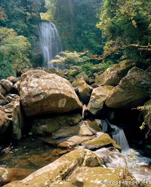
Just a couple of kilometers from the main coastal road between Phuket and Khao Lak (Phang Nga province, southern Thailand) is the waterfall of Khamin. Not located within any protected area little is known of this waterfall, at least on the net. The name is synonymous with the mountain behind it, the 600+ meter high Khao Khamin.

The fall itself is roughly 15 meters high, not a direct fall but on a slight slant. Beneath is a nice pool, albeit somewhat small. Some enhancement has been tried by placing picnic tables. By the sight of all the refuse lying around it is pretty evident that it sees heavy use only not when I was there.

Getting there is pretty straight forward. The falls are located between kilometer markers 36 and 37, two kilometers before the Thung Maphrao by-pass. The road up the hill is roughly 2 kilometer with a small parking spot.

A closer inspection reveals loads of trash ...

Monday, November 23, 2009

Listing

Making lists seems to be a great way of making a total non-relevant comparison. Considering there are more than 60 entries already posted on this site, one mite be tempted to ask, which was the best? And I mite not be able to answer... But I'll try.

During the past week I have actually been trying to remember other places in Southeast Asia where I have enjoyed waterfalls and/or swimming holes. Most though are so far back, that I have no pictures to post and no real memories of them either. They were Tasik Chini in Malyasia (visited in 1990), Khao Sok (1990) as well as a 2004 journey in Khao Yai NP (Hew Narok waterfall) Thailand. That said none though are in the top 10.

Hew Narok

What I tend to like is places less visited / less frequented, with a walk (hate 'drive in' waterfalls), abundant nature and different.

As said the best swimming hole I have known was at Hin Huep, Lao, though essentially nothing exceptional it formed a good part of my life.

In the list I'll concentrate on waterfalls:
1. Tad Xay, Bolikhmxay, Lao. A huge pool, remote, surrounded by nature.
2. Blahmantung, Bali, Indonesia. An energetic walk in, high drop, great scenery.
3. Mae Sapok, Chiang Mai, Thailand. Remote but accessible, low visited, diverse fall area.
4. Huai Phai, Loei, Thailand. Another walk in which means less visitors. Great to mess around in.
5. Lu Du, Satun, Thailand. Forgot, so maybe over romanticized ...
6. Kuang Si. Beautiful.
7. Mo Paeng, Mae Hong Son, Thailand. Interesting surroundings.
8. Huai Hin Phon, Chiang Rai, Thailand. Unknown, quiet.
9. Tad Xe, Luang Prabang, Lao. Accessible, beautiful, vibe.
10. Khlong Nam, Kampaeng Phet, Thailand. Eery beauty.
The most popular waterfalls of Southeast Asia would be something different. In that top 10 would be Erawan, Sarika, Saiyok from Thailand, Kuang Si, Lao, Khone waterfalls on the Mekong, Lao/Cambodia, Gitgit, Bali, Indonesia, Sipiso-piso, Sumatra and many more. Anyone have different suggestions?

Thursday, November 19, 2009

Extending the definition?

Seeing how this web site is increasingly becoming a personal listing of great places to swim and have fun in Southeast Asia with at least some water losing some height. All the while enjoying the naturalness of both the water and the surroundings, I could now embark on putting swimming holes on the list. These are not waterfalls persé, though some occur where there are rapids. But where will it end?

A contentious point that I could do is to include the Siloso Beach Resort, Singapore where I stayed a couple of nights during the opening of the resort in August 2007. The resort has an 18 meter man-made waterfall in their pool, but should it be included? I think not, it's man made and I suppose (hopefully) that the water has been chlorinated and the likes, i.e. there's nothing natural to it anymore.


Back to swimming holes then. Should I? A case in point is the recent inclusion of the posting on Nam Lik, Lao, which I rate as my most enjoyed swim hole experience in Southeast Asia. The reasons though are personal. As the Southeast Asian waterfalls experience for me is not a technical experience (see worldwaterfalldatabase: What is considered a waterfall?), it's about enjoyment which, yes, can be personal. However some waterfalls have the wow factor (great to see, but little to enjoy), others awesome (jumping from rocks, skinny dipping and the likes).
But possibly we getting on a sliding scale.

Is a simple slow flowing but deep river not a swim hole? Good question, it has it's merits. Maybe I should just rename the blog, Enjoying the Natural Waters of Southeast Asia? But then what is natural water? Non-contaminated, free from pollution? And would beaches not be included? Probably not, that might be a great theme for a new blog though ..


Tatai, Koh Kong, Cambodia. This is a great waterhole just north of the rapids.
Can be reached from the Rainbow Lodge. The owner recommends:
'Skinny dipping by moonlight anyone?'
Let's rate, this way readers can see what I look for in waterfalls and the like.
Natural awesomeness: 2
. Natural surroundings: 5. Skinny dipping: 4. Overall experience: 4.

Bohorok River, Bukit Lawang, Sumatra Utara, Indonesia.
Bukit Lawang is a small village, the first village after the Bohorok river has left the Gunung Leuser National Park. Visits to here are popular with locals in the weekend to enjoy the river and nature, whereas tourists stay here as it is the location of an Orang Utan rehabilitation center.
Many guesthouses are located along the river and sleeping is a true delite.
Tubing is also possible, but just jumping around and swimming is as much fun.

Natural awesomeness: 4.
Natural surroundings: 4. Skinny dipping: 0. Overall experience: 3.

Yak Lom, Ratanakiri, Cambodia. See blog post earlier.
Natural awesomeness: 4. Natural surroundings: 4. Skinny dipping: 2 (seclusion is on offer, outside of weekends, early in the day or during sun-down). Overall experience: 4.

Swimming in the Tonle San, between Taveng and Voensai, Ratanakiri, Cambodia.
Natural awesomeness: 2. Natural surroundings: 4. Skinny dipping: 0 Overall experience: 2.

Danau Toba, Sumatra Utara, Indonesia. From Tuk Tuk village.
Natural awesomeness: 4. Natural surroundings: 3. Skinny dipping: 1 (after dark).
Overall experience: 3.

Forgot, not


In my haste to put as much as possible of the waterfalls I have visited in Southeast Asia, a couple have fallen off the track so it seems. One which seems very unique is the waterfall of Angseri, Bali, Indonesia. Where else can you shower under a 7-8 m high waterfall after which you can take a hot soak at an adjacent hot spring? Well, maybe not so unique, but something special.

I have an extensive posting on the hot spring on my Soaking in Southeast Asia blog which seems to sum up most.

Another waterfall is a large waterfall that flows in the Telega Waja river, Bali, Indonesia. As I was rafting at the moment no photo's. Let's download
someone else's:

It's quite high and too powerful to be underneath. Name:?

Monday, November 16, 2009

Why? For the adventure of bathing


Nam Kat refers to a waterfall in Oudomxai province, Lao. Again I managed to forget my camera when hiking here and was hoping that colleagues might fill the void ....

The start to the hike of the falls is roughly 20 km north of Oudomxai town where you take a right turn and continue over a dirt track until the first river crossing. Park here and then it's a one and a half hours walk up along the river into an increasingly narrow valley. In the beginning the track is well defined slowly the track decreases in width, though there route is pretty obvious.

The falls themselves are about 15m high into a large pool with quite a heavy flow of water. I believe I visited in December 2004 on a slightly cloudy day and the water was freezing, so no swim.

However Footprint Laos
reports that visitors:
'... only saw a trickle of water from the falls'.
Never, ever comment on waterfalls in Southeast Asia pre-monsoon.


From the Oudomxai Provincial Tourism Department there is a good description of the waterfall:
'... if you are adventurous, take the time for a bath in the refreshing water of the Nam Kat'.
Can't see what the adventure of bathing in the water was, there were no crocs or anaconda's or things like that ...


Then there's the Lao National Tourism Administration :
'Why should I go to the Nam Kat Waterfall?
[Answer:] Discover the Heart of Northern Lao Why rush on, pass a wonderful day in the nature near Oudomxay'.
I know that in the past there was a threat of this area becoming 'developed' which would have included the likes of a resort possibly a casino, it's good to see it is still in it's natural state.

Elsewhere in the province there is the Lak Sip-et waterfall, or rephrased the 11km waterfall, which unsurprisingly is 11km up the road to Luang Prabang. Packed on holidays, these better accessible waterfalls are also less pristine and less impressive.

Sunday, November 15, 2009

Best

After posting nearly all my experiences with waterfalls in Southeast Asia, one would be inclined to ask what was the best?
Each has it's own peculiarities. By now the reader should have understood my penchant for seclusion and nature, though there's nothing better than enjoying a place with friends.

Ironically, I have never taken pictures of my best place and most frequented place. It's where I went for a refreshing dip was a swimming hole just south of the bridge of Hin Heup, Vientiane province Lao. See above picture taken from the bridge looking downstream. The swimming hole is all upstream of where the river disappears from sight.

Working late nearby I would quit after darkness had drawn, hop on the moto and drive up to the village and down to the pebbly bank. Off with the engine and let the sounds (or the lack of them) envelope me (and see if anyone is around). Then a quick strip and into the dark water. Just above a rapid in the Nam Lik a large lake exists, 8-9 months of the year at least.
Refreshing at most times of the year (even cold in December / January) I would swim across the river to a number of large rocks where you can sit on and gaze up at the moon and stars listening to the sounds around. Sometimes there would be skin divers with their lights and laughter. Always the silence would be broken by the occasional car or truck rumbling over the bridge to the north. The bridge existing of metal plates, it would make a hell of a noise, but only lasted a few seconds after which one can savour the quietness.


Hin Huep bridge (photo taken from upstream),
the site where a armistice was signed as well as the later stampede
in which many Hmong refugees fell off the bridge or were trampled (
source).

Despite the skin divers, the swimming hole would be deserted, though come here during the process of sun down the whole village would here bathing and splashing about. Moto's and cars getting a wash. Come dark every one would head home.

A natural dip? In Lao? But surely that's not done. Actually it is. Development not yet national means that in-house running water is quite often non-existent, meaning everyone is bathing in the rivers or near water points. And not everybody seems to have been cautioned about the negatives of showing one's body ('R there any?). Even where I swam, occasionally locals would come out skinny dipping. I remember on one occasional a boy with his girlfriend, chiding her for revealing herself to me. Quite rightly she replied that the foreigner couldn't see a thing (right, no moon) and was used to it (right). But she didn't know I could understand what she said ....

So would I recommend the hordes to visit Hin Huep? It's a beautiful place despite the road running through. The swimming hole described above is probably now directly under the new bridge. And other than hanging around there's not much to do, though it would be a great place to set eco-adventures. Already the swimming hole is used as basis for rafting and kayaking downstream. One could also go upstream and drift back down. To the east and west are great hiking areas while to the south west and northwest are great places for mountain biking, not too strenuous but with beautiful scenery. Combined with the many quaint and traditional villages, it would make Vang Vieng look boring ...

Wednesday, November 11, 2009

Nibbles


Erawan waterfall is rated as Thailand's most famous, most popular and less fortunately it's also the best visited (Elliott, S. & G. Cubitt - The National Parks and other wild places of Thailand. 2001).

The Erawan falls are the namesake of the surrounding national park (don't forget hefty entrance fee); Erawan itself named after Indra, an elephant with three heads which is believed to have transported Bhuddha from the state of enlightment back to the world of ordinary people (source) .
During the monsoon the top level of the 7 levels has three sepearte streams, hence the name, the waterfalls resembling the three trunks.

Each of the levels are only just a few meters in height, some with a plunge pool beneath.

Visited in August 2009 and on a weekday the park and falls were not too overrun. In each pool along the way several tourists were swimming, seemingly undisturbed by the frisky carp which tend to nibble at the swimmers.

A subdued son; no fun swimming with fish feeding on you. Bummer!

From Kanchanaburi take highway 3199 and keep following the signs. there is a monstrously big car park and even a real market a km away, so refreshemnts are always availble. There are a number of resorts nearby, but Erawan lies conveniently to most Kanchanaburi located staying options.

Tuesday, November 10, 2009

Waterfalls everywhere


Kanchanaburi, Dai Chong Thong waterfall and Kroeng Krawia (Kreng Kra Wia or other variations) are two good accessible waterfalls in western Kanchanburi, Thailand. Both located in Khao Laem National Park, no entrance fee is required to visit these falls.

Kroeng Krawia lies directly along the road to Sangkhlaburi (on the border with Burma, home of Thailand's longest wooden bridge) which is roughly 30 km away. Good rest facilities exist at these falls, though lodging would be available in Sangkhlaburi or Thong Pha Phum, 35 km back the other way. From Kanchanaburi it is 190 km at least.

The Kroeng Krawia falls jump over low heights (1-2 m) as the stream finds it's way through the forest.

Dai Chong Thong waterfall is walkable from the parking area of Kroeng Krawia, take the side road up for 500 m, then take a left for another 500 m until you hit the stream, it should be more down stream. When we visited back in August 2009, it was during and just after heavy rainfall and the stream was flooding such that there were waterfalls everywhere.

High but not highest


One of Lao’s area’s where a multitude of waterfalls are to be seen is the Bolaven plateau situated in the southern province of Champasak. Access to this volcanic area is from Paxé, south Lao’s major entreport. There are a few resorts on the Bolaven itself, a gradual climb from Paxé.

I’ve stayed in
Tad Fane Resort (named after the adjoining waterfall) which sits on a ledge of the Bolaven with view of the 100m high waterfall opposite and below. Going down is not advised, it’s that steep. It is located 38 km due east from Paxé on the road to Paksong, Lao’s coffee capital.

Other falls on or from the Bolaven are Tat Lo, more to the north on the Bolaven and Tat Feak and Tat Se Noi (the former visited), both in Sekong province, further eastwards. While there is also Lao's highest the 120m high Tad Katamtok.

Monday, November 9, 2009

More unknown

Located along the old road to Bentong (of the unremarkable hot springs fame) even the best website in Southeast Asia on waterfalls mentions this as 'unknown':
'This nice unnamed waterfall can be seen from the road. Will be powerful in the rainy season'.
SerenDIpiTy claims the same:
'We exited at Genting Sempah and use the Janda Baik road to link to Gombak-Bentong road. From here you will pass the unnamed waterfall'.
It's a good view from the road, but that's about it.

Beware

Though it was much more a search for a nearby hot spring somehow we included this waterfall in the sights seen. Known as Sungai Sendat waterfall, it is 5 km out of Hulu Yam Baharu which itself is about half an hour out of Malaysia’s capital of Kuala Lumpur.

Though there is ample evidence that the place is overrun during certain times, when we visited in August 2008, not a soul was to be seen. Just their trash. The pool pictured above certainly looked appetizing but with the amounts of refuse nearby I was not enticed at all to dive in. Above this main fall are a series of smaller falls, the further away one gets from the main car park the more natural the surroundings become.


Probably on the odd days where there are hordes so there will also be lines of local caterers, but such was the case that day there was nada. It’s so close to KL that staying overnite is not really called for.


Waterfalls of Malaysia's entry on Sungai Sendat contains a stark report of a drowning here ...

Rapid

Again not really a waterfall but rapids. O’Russey Kandal (or O'Russei Kandal) in Cambodia’s northernmost province of Stung Treng offers a nice place to get away from it all. Around the rapids an area of forest is being protected from land grab and / or speculation by a project intended to develop and popularize the rapids without effecting the environment. The village in cooperation with local national NGO Mlup Baitong has set aside some walking trails, rent outs bikes as well as arranges overnite stays. More info on the project's workings can be found in this article in the Cambodian Scene. Another initiative includes this site in the Mekong Discovery Trail.

O’Russey Kandal is 28 km south of the provincial capital just before you go over a bridge. Go to the east for 500m until you reach the car park.

The rapids are quite dependent on rainfall, below you can see that in April 2009 water levels were low, but still enough for a splash around. It being a weekday visitors were low.

After a long way in the car great for a cooling dip.

Sunday, November 8, 2009

Making Beautiful


The most heavily touristed waterfall on Bali and thus most probably the same applies for the whole of Southeast Asia are the Gitgit falls. They have much what makes waterfalls beautiful: nice pools, high falls, lush growth, etc. But that is often devalued by the masses of tourists who visit this 45-60 m high waterfall due to it’s ease of access next to the main cross island road. Though lacking in a huge car park, there is enough space unless it’s a festival day. Entrance fees are required after which a cement track takes you above and around the falls. There are quite a few warungs and some aggressive sellers. Though nowhere as bad as say on Kuta.

The Gitgit falls are just 11 km south of Singaraja the island state’s capital on the way to the central town of Bedugul. Accommodation is to be had or near the black sands of Lovina to the west of Singaraja.

A word of caution:
'The local legend is that if couples swim under the Git Git falls, they are bound to be separated so for those travelling with partners, beware!'

Uncertain


To be honest, I don’t remember how we got here, I do know it is in Wang Chao National Park, Thailand. Direct access was poor, one needed to park on the main road and walk down hoping to find the falls. As you can see at the moment we visited (November 2008) there was not too much flow from the 5 m high fall. Beware though most of the flow comes from the opposite side Probably at the height of the rainy season it would be a good view. An au-naturel was called for.

Actually while looking for more pointers on the net I am now unsure whether it is the Wang Chao waterfall, certainly it is in the Wang Chao National Park. My
reference adds it is 100 m high, ... not!

Wang Chao National Park is located to the northwest of Kamphaeng Phet town, though access may be just as good from Tak to the north. Don't get too confused the town of Wang Chao is in Tak province, the national park is in Kamphaeng Phet. Access roads are highways 1109 or 1116 from the main A2 highway north.

Staying is good in recommended
Scenic Riverside Resort in Kamphaeng Phet.

Saturday, November 7, 2009

Unknown


A fall with no name. As happens this fall is probably totally untouristed and as such does not need a name. Far from the maddening crowds, this 3 m high fall is only reachable with two wheels or two feet. Actually the track fords the river over the rocks directly above the falls. The track connecting a number of village’s sees little traffic and the falls thus see even less visitors. One needs to scramble through the undergrowth below the falls. Though not necessarily a great pool, on a hot April 2009 afternoon this made for a great naturally enjoyed shower.


Getting to this remote fall requires some effort. For one it is in Ratanakiri province, one of the remoter parts of Cambodia. Best place to stay is one of Cambodia's few eco-lodges, Yaklom Hill Lodge. It is here where possibly more info will be provided as to where to get to this waterfall. (Phume Kres village?) All I can remember was that it was north and then a right turn roughly 10 km out of town and just keep on going.

Than Thip


Thailand’s Isaan is not well known for it’s waterfalls, it’s a very flat and dry area. Nonetheless Nong Khai province south of the Lao border and thus the mighty Mekong, does contain a few waterfalls, predominantly to the east. Access is best from the road 211 to Loei, hugging the southern bank of the Mekong. At first this road is a wide thing connecting smaller towns with the provincial capital but slowly the road narrows and becomes windy.

The river village of Sangkhom is probably the closest area for accommodation and facilities if visiting Than Thip waterfall (faded pictured above). Having two (or three?) tiers with a big pool between the two this was my first introduction to the park like landscape gardening to which Thai seem accustomed when visiting a natural highlite. On our visit in late 2002 the place was virtually deserted but again the car park mite be wishing for more.

Nearby is Than Thong waterfall.

Bo Wi


Bo Wi waterfalls is another Ratchaburi (Thailand) set of waterfalls only recently accessible to the general public. Located quite a bit away from local concentrations of people as well as an extra 30 km from Bangkok, it sees relatively little amounts of visitors. There is a car park though but with only limited space.

The falls themselves continue for 9 steps with varying heights and varying sizes of pools beneath. The half hour path up is well trodden.

Again not really a place for a swim, certainly not in April (2008) but good enough for a cooling down.


Lodging and food is not available nearby, stay near Suan Pheung.

Chaa .... Ong


Cambodia’s Ratanakiri province has some problems naming waterfalls it seems; there’s quite some indecision concerning the correct spelling. Often the names used are derived from local tribe languages and translated to Cambodian sounds which are then translated into something recognizable for the foreign tourist. Along the way weird things happen spelling's wise.

Chah-ohng (or Chaa Ong) is a waterfall not far out of the main provincial capital, Banlung. Head due west for 2 km then go north for another 2 km, take the left fork and continue for another 3 km. You will arrive at a car park where a nominal sum is required for entry. The car park is just beyond the upper ledge of the fall.

The fall themselves are about 10 m high. Basically the water pours over a ledge and falls on the rocks below. Unique to these falls are the area behind the waterfall (and beneath the ledge) which are hollowed out. Probably this is why they are mentioned as impressive....

Our visit in April 2009 though coincided with little flow and as such the waterfall was not so very impressive.

Anyone for ice-cream?


Khlong Nam Lai waterfall is located in the same national park as the aforementioned, Khlong Lan waterfall. Located about 20 km closer to provincial capital of Kamphaeng Phet it sees a lot less tourists. On a late November afternoon in 2008 the large car park was deserted save for an ice-cream seller. There is though a big car park evidence of megalomania or an indication of visitors during more days. Around the car park and the lower reaches of the falls is a huge park area.

The waterfall (which translates as waterfall with much water or very beautiful!) counts no less than 9 levels, each between 15 and 30 m. Somehow someone has decided that only the first three levels can be visited, the others are off limits due to safety reasons…. Between the three levels are large pools with very cold water (visit was in November 2008), good for a momentary freeze …. As with the Khlong Lan waterfall, more facilities are available in Kamphaeng Phet.

Sunny Blur does not recommend this place:
'Klong Nam Lai is nice, but not worth the trip'.

Getting here requires following the 1117 out of Kamphaeng Phet uptil the market village of Khlong Nam Lai where a right turn and another 8 km gets you to above mentioned car park.

Kao Chon with an o

The area’s west and south of Suan Pheung, Ratchaburi province, Thailand are a relatively undiscovered area not even far from Bangkok. Due to the area being close to Burma much of the area was actually off-limits to outsiders. This has recently changed and since more and more tourists are arriving, mostly looking for ways to enjoy the natural surroundings. Especially the hot spring of Bo Klueng is becoming a must see place. Nearby are a number of smaller resorts such as the nice Scenery Resort and Nagaya, though more were being constructed when I visited there (April 2008).

Just a km upstream from aforementioned hot spring are the falls of Pha Daeng or alternatively named as Kao Chan / Kao Chon / Kao Krachon. They can be reached via the road and there is a big car park being testament to busier times. Otherwise one can take a half hour trail from the hot spring and get to the falls about 2 or 3 stages upwards of the car park.

From Wikitravel's Ratchaburi provincal guide::
'It is a medium-sized waterfall with a height of 7 layers. The water flows from the high cliff in the middle of the valley all year round. The quantity of water increases in the higher levels. Rocks in this area are granites. Previously, this waterfall was known only among Karens; later, foreign companies came and got concessions to operate the mine around 1941. After the concession contract was terminated, the district and local organizations were responsible for maintaining the area'.
It being the end of an exceedingly hot day and no one about, the pools were good enough for a great dip, but with the flow at it’s smallest much more than a dip is not possible.

From Ratchaburi city, take highway no. 3087, just north of Ratchaburi on motorway no. 4. The 3087 bypasses the town of Chombung and after a gradual climb you'll find yourself in the town of Suan Phueng.
Bo Klueng however is a well signposted left turn, 5 km further out of Suan Pheung still on the same highway, 3087. The hot springs are about 10 km from this intersection, on your left. The Pha Daeng / Kao Chan waterfalls are at the end of this road, 1 km beyond the hot springs.


Update: Revisited these falls in December 2009. Despite there being quite a few visitors, there are in all nine levels to enjoy. So if you escape the crowds you can well have a fall to yourself, the ninth level being nearly ninety minutes from level 1.

Having your own skinny dip spot at level nine Kao Chon.

Elsewhere the area upstream of Suan Phueng is rapidly becoming a tourist hot spot, many resorts and coffee shops. No foreign tourists as of yet. More on the local hot spring.

Thursday, November 5, 2009

Prior Occupation


Cambodia’s better known national park, Kirirom, contains a number of smaller falls situated around the mountain top. Getting here is quite straight forward. From Traeng Trayeung (75 km from Phnom Penh in Kampong Speu province) veer off to the west of the main national highway between Sihanoukville and Phnom Penh. Keep going along this pot-holed tarmac road. After paying the entrance fee, the road will start it’s ascent to Kirirom proper, a high plateau (> 675m) with pine trees and a crisper air.

Visited in 2006 on a February week day, the area was eerily quiet. However there are a few no name waterfall sites on top which seem to cater to non-existent armies who are dedicated to leaving behind their tell-tale signs of prior occupation. Stalls are all over the place and must open up for bizniz in the weekend when I would say the place is to be avoided.

There is a resort located near the entrance of Kirirom National Park (Hillside resort) as well as the community based eco-tourism site of Chambok.

Good?


Nam Dee (Nam Di) translates as good water. Not too far from Luang Namtha town it’s a great cycle ride there. The local village with the same name as the waterfall is inhabited by mostly Lanten with their distinctive dark blue / black clothing.

We visited here December 2007. Getting here is not too difficult, there is a road that circles the valley on the north, Ban Nam Dee is just off this tarmac road, on a 1 km long track, in total around 6 km from the provincial capital. Said otherwise head in the direction of Muang Sing and take at the first cross road the road to your right, cross the bridge and then the first track on your left. The not awe inspiring waterfall is another 1 km further.


Facilities are not to be had, however Luang Namtha itself has a variety of lodging facilities as well as caterers. Try the award winning Boat Landing, an outstanding community eco-resort south in the Namtha valley.

The area around Namtha is excellent for trekking, canoeing and biking, with much undisturbed forest as well as many different tribes. Green Discovery has one of the best set ups for anything in Southeast Asia, let alone in Lao.

Another good blog entry by Andy Brouwer who by chance lives just up the street from myself.
Related Posts with Thumbnails