Waterfalls are often described in superlatives. Beautiful, incredible, powerful, tremendous.
Or be for it's characteristics. Highest, widest, biggest.
Historic
It's not often that one would say that a waterfall is 'historic'. I've been racking my brains to find a 'historic' waterfall, but other than waterfalls which became history (now hydro-electric generating plants) or waterfalls in regions seeped in history (Schaffhausen) I don't believe that there is a waterfall that can lay claim to be at the foundation of a kingdom/empire.
And exactly that is what is claimed by the waterfall of the Phnom Kulen (or Ku Len, which translates to mountain of the lychee) mountains in Cambodia's Siem Reap province.
Wikipedia describes the historic event as
'it was at Phnom Kulen that King Jayavarma II proclaimed independence from Java in 802 A.D.'Or in other words, here was were the Khmer nation (some say empire ...) was born.
Apparently it became the first place where a settlement was erected and only after a century was it decided to leave the mountains for the plains of Siem Reap to rule and eventually construct numerous temples and complexes, the most famous relic being Angkor Wat.
So you can imagine what belief this waterfall holds for current day Cambodians.
Lush
Phnom Kulen waterfall can be found in the mountains with the same name. Located about 50 km northeast of Siem Reap, one is surprised by the lush vegetation in what is arguably a very dry area; the mountains are also not very high, averaging just over 400m above sea level.
Getting here involves taking the road to Anlong Veng (from Siem Reap) or the older road to the temples of Banteay Srei. Just beyond Banteay Srei you hit the new road to Anlong Veng on a roundabout in the middle of nowhere which is about 500 m in diameter (seriously). One then takes the eastern most road and after 50m the tarmac stops and one is on a not so bad gravel road. Ten km's up this road, one comes to the gate, the entrance to Phnom Kulen National Park.
 The upper fall
Until about a decade ago the waterfall required considerable effort to visit. Then came the idea to put in a road which was awarded to some military official, who now has the right to rule his fiefdom. This means he can charge $20 US per foreigner for the privilege of using his very difficult rough and tumble (but do-able) road up the mont. And absurdly pay another 3,000 Riel (0,75 $US) at the top as a parking fee; what that actually entails is a mystery as vehicles are parked haphazardly between trees. Oh well, that must be how the Cambodian empire started.
Crossroads
After paying the parking fee, one is at a crossroad. Here are three highlights. The waterfall is left, the reclining Buddha is straight ahead while the 1,000 linga's are also over the bridge then right.
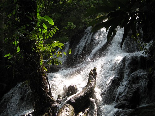
We first head to the waterfall and park the car in some shade. Head towards some buildings. Here at the top of the waterfall are a great number of restaurants and rest huts. We are set upon by a group of ladies intent on selling us lunch, even though it's just 10 in the morning. We feign disinterest and head through the throng. First we see a minor waterfall to the right.
Beyond the tree lined lip lies the waterfall itself. We can walk down over wooden steps to the rocks below the 30m high waterfall. Once at the bottom of the waterfall one can scramble along the boulders to cool off under a large pool in the center. Along the sides below the falls, commercialism is still in force, bathing costumes can be purchased, changing rooms and the possibilities to dress up like a local Mondulkiri tribes person (see lead photo) and get one's picture taken are just some of the diversions created to part with one's cash.
 The major falls
Added to the rubbish, shops and sellers is a surprising amount of Cambodia's doubtless masses of unemployed eagerly awaiting a tip for their nuisance of begging. Elsewhere others simply tag on to you like a leech and expect a fee for services rendered (guide?). Not my kind of place ...
Ruined
So, what's historic? Just on the other side of the upper part of the falls are original ruins. The ruins go by the name of Prasat Krau Romneas, apparently dating back to the ninth century.
Not much has been done, or let's say nothing has been done to make this more appealing or, god forbid, protect it from the ravages of tourism. The entry fee only goes so far. Probably adds to someone being able to cruise Phnom Penh in their new Lexus.
Furthermore about 500 m away is the 400+ year old sleeping Buddha on top of a rocky point. More info on this Buddha from Andy Brouwer. A visit is a must if only for the view over the surrounding jungle.
At the foot of this temple is the site where one can rent a moto (and driver) to visit some of the mostly remoter sites on the mountain; a real treasure trove apparently for the more adventurous. For instance: Shra Damrei and Peung Tbal.
Better still, wander down to the river, where the original occupants decided to elaborate the river. It's about 300m above the top fall. Over a stretch of 200m they have built linga's, the site known as 1,000 linga's.
Wikipedia:
'The site is known for its carvings representing fertility and its waters which hold special significance to Hindus. Just 5 cm under the water's surface over 1000 small carvings are etched into the sandstone riverbed. The waters are regarded as holy, given that Jayavarman II chose to bathe in the river, and had the river diverted so that the stone bed could be carved'.The good entry in peaceofangkorweb laments:
'The 1000 Lingas pre date the ones at Kbal Spean, They are not so extensive or even protected from he feet of locals crossing the river'.As well as observing the linga's one passes a meter deep spring which by the sight of the make-shift temples holds some current day religious significance. One must note though that as Khmer nowadays are Buddhists but back then they were Hindu's who traditionally hold springs in high esteem as forces of purification.
 Just a couple of the thousands of linga's
 Internet
As one can deduce protection of Kulen has yet to commence. The Phnom Kulen Program hopes to better understand the significance of Kulen.

On the internet there is plenty of other info, visit records and photo's ... Most significant are besides the aforementioned blog entries by Andy Brouwer, his 1999 record of a visit here. Surprisingly not much (positives) has changed since then ....