Wednesday, October 28, 2009

Atmospheric


Khlong Lan, Kamphaeng Phet province, is another of Thailand’s drive in waterfalls. Visited in November 2008 the falls were huge (40 m across, 100m high) and freezing. Wind was wipping a mist which certainly added to the atmosphere but not to the desire to take to the waters. The falls are located smackbang next to the National Park headquarters, with a car park having ample space for even coaches. A few stalls nearby are selling and serving.

Kampheang Phet, the name of the provincial capital as well, is itself about 45 minutes drive away. Take the main highway south to km 346 and then follow road number 1117 for 40 km. From here an entrance road continues to the falls over a distance of 6 km.

The town has a wide variety of accommodation styles as well as sufficient restaurants. One of the best places I have stayed in Thailand is also to be found,the Scenic Riverside Resort. The town has some ruins quite near the center.

Tad Duen


Though Sukhothai province, Thailand is well known for it’s ancient and historic ruins, it’s natural surroundings are also worth a visit. Sukhothai contains amongst others two beautiful national parks. They are not always as accessible but fun still the same.

About 35 km from the Sri Satchanalai ruins is the
National Park with the same name. There is a double waterfall (Tad Dao) that can be visited though it’s a 2 hour walk from the park headquarters and visitors are not allowed to go there after a certain time in the afternoon so as to avoid tourists camping out there.

Close to the park headquaters though is a different waterfall by the name of Tad Duen (or Tad Duean, Doeun). Visited in November 2008 yet again the place was deserted. With a strong flow and a beautiful pool beneath the 10m high fall nothing could stop me from a skinny dip.


Sri Satchanalai has some lodging (as does the national park) and some nice places to eat, but otherwise head for Sukhothai itself even though it’s 1,5 hours drive away.

Tuesday, October 27, 2009

Where?

And what would the name be of this waterfall? I don’t have much to go on. It’s in Loei province, Thailand and the photo taken was back in 2002.

A first?

Access to Tadtong waterfalls near Luang Prabang, Lao is quite unique in Southeast Asia. Located behind a water bottling company, it has a huge car park next to a pond. There is also just the singular canteen. From here the canteen a concrete path actually goes into the hills upstream. Along the way are a number of smaller falls. On some stretches the concrete has given way (this December 2007) but still the whole path is estimated to be 3 km long, eventually returning to the bigger fall near the canteen. Besides the unappetizing pond there is not much opportunity for a swim. It’s more a splashing around kind of place, mostly visited by locals, it not being part of Luang Prabang’s tourist trail.

Getting here is not too difficult; the turnoff is directly south before the bottling plant itself, roughly 10 km in the direction of Vientiane. From the main road it is just 1 km at the most. Lodging is available in Luang Prabang, the canteen might not always be open.

A Bali high

A very beautiful walk to a great waterfall is the walk on Bali, Indonesia to Blahmantung waterfall (or Blehmantung). On the cross island road from Antosari to Seririt roughly half way is the village of Pujungan. A side road in the village goes slightly uphill eastwards. In better times one can continue driving over the road, but there are very steep patches as well as muddy areas.

So when we visited in January 2009, we parked the car not far from the main road and continued on foot. From the crest one then descends back to the lowest place in the valley, the river. Shortly before the river there is an irrigation canal on your right, take this and follow until it’s inlet. From here one needs to continue on passing through a plantation and forest until it’s obvious where the 50m high waterfall is, some say Bali's highest.


There is a smallish pool, great to plunge in nudey style with the thundering fall behind you, especially after the hour long trek. And a full body search for leeches picked up on the way there …

Another good first hand description by Cornish Travellers.


It’s quite untouristed (still). The nearby town of Pupuan has some facilities. Back south, about 5 kms is the excellent Bukit Sanda’s Villa resort built on a coffee plantation. Though a bit stiffly priced it is certainly worth it. Fine lunches are also to be had. They also provide maps of the walk to visitors.

Additionally Bukit Sanda has an info sheet on how to get here:
'Are the falls named Blahmantung or Blehmantung? Who knows and the locals can’t make up their minds either, as a matter of fact, they call them Slingsing'.
Then follows a whole historic account of the erection of a number of signboards and some advice on shoes and transport. Finally the trek starts:
'You are ready to start your trek. The first couple of hundred metres or so take you out past dozens of barking and yapping dogs. Ignore them completely and they will lose interest in you. Out on the track you will pass large rice paddies on your left. You will also walk past a ‘mandi’ on the right of the road. You should ignore bathing beauties (of either sex) unless they call out a greeting to you'.
The info sheet then guides the visitor exactly to the falls. On the flipside it has a very accurate map.

Other visitors enjoying the same falls as nature decrees, by Balilogue

More from Ratanakiri


Closeby to yesterdays posted waterfall of Ka Chanh is the Katieng (or Ka Tieng) waterfall in Ratanakiri province, Cambodia. So close that both can be visited within an hour of Ratanakiri’s provincial capital of Banlung. Again take the road out of town west for 2 km then roughly 3,5 km to the south just beyond a school is a dirt track veering off to your right. Keep following this track past cashew nut plantations (with the possibility of taking an elephant) until the road descends over a rutted track. In all from the turn it’s about 1,5 km.

From the food stalls it is pretty obvious that you have arrived though the road proper fords the stream and continues onwards. A small entrance fee is required. Above the 10 m high fall is a large park like area. Off to the left is a trail that leads to a staircase to the huge pool below well worth a great swim.

Again avoid weekends and you'll probably be alone. See above link for more info on Banlung

Back then

A post entry without photo? Kinda lost the few photo's I had. In 1990 I spent a couple of days camping on the coast of Ko Tarutao, a then quite remote island of Satun province's coast.

Inland was what was then known as the non-name waterfall. It was an hour long scramble to get there a sort of a trail cris-crossing the stream. At the end was a 4 m waterfall, but no pool. However if I look at recent photo's on i-net they all claim that there's a pool. Funny back then we stripped and took a shower. Nowadays it doesn't seem to the custom, and though I acknowledge that it's not that remote anymore it still is way way away from what can be called civilization ...

Part of a National Marine Park, Ko Tarutao can be reached by boot from Pak Ba within 2 hours. On the island there is limited accommodation with some food and drinks available. The Lu Du fall is accessible from Ao San beach. Nearby is also Lo Po waterfall, which is even less visited ... Maybe we went there?

Monday, October 26, 2009

Nice


One of the nicest waterfalls I've been to is Mae Sapok. Located in Chiang Mai province, Thailand, I'm unsure whether it's because it was really nice or was totally deserted or possibly both. It was a nice and sunny November day, back in 2006 which might have helped.

From Chiang Mai go south on the 108, then in Sampatong, turn right and continue up the 1013. Past the elephant camps and bamboo rafting sites. Roughly 40 km up the road there is a small road to the left which brings to a small restaurant from wher the main fall is about 10 minutes walk. The roughly 10m high Mae Sapok waterfalll is part of Ob Khan National Park.

Below the waterfall is not really a pool, but the stream continues down hill for another 200m where you will find a 200m long pool, great for a swim.


There is a cafe serving mostly drinks nearby in the village and not far away was a resort which did not seem to be very active. On the way there area number of elephant camps and rafting possibilties if the water is sufficient.

Ka Chanh


Ratanakiri is a province in Cambodia's Northeast bordering both Lao and Vietnam. Long cut off from the rest of the country and a battleground during the Vietnam war, it is slowly becoming a destination of it's own despite foor transport facilities. Attractions are a mild climate, various tribes and some outstanding nature. However slowly this nature is disappearing as the primary forest is being replaced by extensive rubber plantations, changes which also result in the increased marginalisation of the original inhabitants.


The province contains many beautiful waterfalls, many still waiting to be discovered. Near Banlung (the provincial capital) local waterfalls are already well established on the tourist trail. We were there this April co-inciding with the nation's New Year celebrations. So the waterfalls around Banlung were well visited, avoiding the crowds by going early morning is just one solution.

One of the best accessible waterfalls is known by Kan Chang, Kinchaan, Kah Chahng Ka Chanh and / or Katchang. I've decided to proceed with Ka Chanh, which had the most hits with google as well as was used by Wikipedia. Lonely Planet though persists with Kinchaan which seems quite beside the pronunciation.

Ka Chanh is located just 6 km from the town center, two km back on the road to Stung Treng and then 4 km south. It is very clearly signposted and there is a big car park for which an entrance fee is required. The day we visited many kids were jumping around in the pool beneath the 7 m high falls which had been rejuvenated by recent rainfall.

Food and drinks are available locally. Banlung is the place to stay overnite. Try the Yaklom Hill Lodge, an ecolodge 2 kms out of town, for solitude and silence.

For another great experience
go for a skinny dip at the 700,000 year old Yeak Loam volcanic lake, at the end of the day.
Nice cool water.
Go any other time of the day it's packed beyond description.


More photo's of Ka Chanh falls on the seasoakingwaterfalls photo web site.

Provincial highs


Another high fall, seventy meters is the estimate and Chiang Rai province's highest fall. Named Khun Kon (or Khun Gon or even Tat Mok(!)), it's not too far from the provincial capital. Located in a Lam Nam Kok National Park, Khun Kon can be reached by taking Highway No.1211 from Chiang Rai town. After traveling 18 kilometers turn right and proceed for another 12 kilometers. From the park entrance it's just 20 minute walk to the falls themselves. Again not necessarily a place to go for swimming.

Accommodation and food is best to be had in Chiang Rai itself.

Though deserted when we visited, apparently with New Year crowds are to be had. The pool beneath the fall is then more accessible than when we visited in November 2007.

Sunday, October 25, 2009

Spinal injuries ...


Mae Pan waterfall is a high waterfall on the east side of Doi Inthanon National Park, Chiang Mai province, Thailand. It is believed to be the province's tallest (100 m) and is essentially a thundering fall with little opportunity for a plunge.

If coming from Chiang Mai keep going on highway 1009, which becomes highway 1192, rather than entering the national park itself. It's about 10 km from the main entrance gate on the northern side. Once past this gate the road gets steep, very steep not so much fun for coming back. Apparently not to be used in the wet.

We visited it on a rainy day back in November '06. It's a nice walk. The nearby ranger station has not much to offer. Accommodation and food is possibly better in Mae Chaem or above near the national park entrance.

Scary is the picture below. why would anyone like to do this? The answer can possibly found here, though there's also the mention of a spinal injury ...

Thursday, October 22, 2009

Butterflies


The Pa La-U (or Pala-U) waterfalls lie due east of the Thai seaside resort town of Hua Hin, Prachuap Khiri Khan province. Part of Kaeng Krachan National Park (remember about the entrance fee), the falls count eleven to sixteen steps as the stream drops from the mountains straddling the Thai-Burmese border to the flat coastal plains. Still containing primary rainforest the area is famed for it's butterflies.

Visited in January 2008 these falls are increasingly a part of the tourist trail. A road goes directly west (3219) from Hua Hin towards the park entrance and parking area (approx. 60 km). From here one is almost at the first step. For more solitude and exercise going beyond this step is required. The above photo is from the third step, the photo below is from the fourth step.

There is a small canteen for snacks, no lodging facilities nearby. The lower fall pools contain fish for which fish food can be purchased. Monkeys also are parked at the car-park.
'Several of the girls in this group were not at all amused by the hundreds of carp that have grown familiar with the tourists who bring fish food with them to the falls. My fishing techniques were crude, but I got my hands around several of these fish. Happily for them, they are all still safely huddled in there schools awaiting the next group of tourists and their handouts'.
Tourist tales.

Another naming problem


Known as Asia's answer to the Niagara, the Mekong falls straddling the Lao-Cambodian border are known by a variety of names. One problem in this name, is that the area over which the Mekong river drops is 14 km wide, partially on the border, partially inside Lao. The Mekong meanders here. There a number of different channels with their own distinctive falls during the drier months. However during the monsoon these separate falls combine to form one major fast flowing fall. Just look at the photo above, taken in April 2009: the barren rocks will be covered by water in latter months and the main channel sees water tumbling in from all sides.

In short it's difficult to assign a name to the fall above. The photo above however is the western most channel with everything below the fall and due west Cambodian, while all upstream area is Lao. Therefore it seems not unreasonable to use the Cambodian name. An old French map mentions this as "Chute de Salaphet" or Salaphet falls, though if you google this there seems to be some credibility lacking to this assertion.

This lack of credibility is partially explained by it's remoteness. On the west shore of the Mekong in Cambodia there are no roads, the roads north to Lao straddling the opposite shore. Lack of access means lack of tourists means lack of mentions on web sites. However on the Lao side, other channels are mentioned as the Mekong falls of Khon(e) and Papheng (falls here are 300m wide and fall 15 m). This is hardly surprising as this area of the Mekong has been a tourist destination otherwise known as 'Sipandone', the Four Thousand Islands. Additional attractions are besides a very relaxing atmosphere a former railway and dolphin watching. The Lao side contains a wide range of lodging and is often included on various tours.

Though I mentioned these falls as Asia's Niagara, the truth is Niagara is America's Mekong Falls:
'This monstrous segmented waterfall on the Mekong River near the Cambodian border in the extreme southern part of Laos is the widest in the world, stretching to as much as 14 kilometers wide during the monsoon season! ... The Khone has the greatest volume of the world’s waterfalls, its 2,500,000 gallons (9,500,000 litres) per second being nearly double that of Niagara Falls'.
Source

Visits to the above and below photographed channel are being organised by the Cambodian NGO Mlup Baitong which is assisting a local village (Preah Rumkel) in dealing with tourists, gaining revenue with the objective of protecting the forests around the falls. This is partially supported by the Mekong Discovery trail. The best way to visit is by arranging beforehand transport to Ou Svay and meeting up with a boat there. From Ou Svay it still is a 2 hour journey to Salaphet falls. Along the way there is a big chance of spotting dolphins.

Pha Tad


Kanchanaburi located 2 hours drive from Thailand's capital of Bangkok forms the base for a number of outdoor pursuits, though most are drive-in / arm-chair pursuits. There are a number of hot springs and waterfalls, lakes and rivers to be viewed / experienced. More importantly there is a good selection of accommodation throughout the province.

Pha Tad (or Pha Tat) is located well upstream of Kanchanaburi town, 140 km actually. To get there, take Highway 323 towards the Burmese border and turn between km 105 and 106 towards the same direction as Hin Dat Hot Spring and continue for some 10 km further. Pha Tad is located in a national park (Kheaun Sri Nakarin National Park).

After the entrance the is large parking area, facilities (incl. a canteen) and a large grassy area. Beyond that there are two forks with waterfalls, where the water thunders between the forest. When we visited (August 2009) it had just rained a lot so maybe that was the reason of the thunder.

Probably one could plunge/shower around.


Swirling Clouds

Bokor mountain is a well known mountain side resort near Kampot, Cambodia. Better is to speak in past tense or in future tense, because at the moment that I'm posting this, access is restricted as one of Cambodia's wealthiest tries to revamp the former home of this nation's pokies.

But why would the gamblers flock to this mountain top only to make losses? Better is to take profit from the natural surroundings which are outstanding.

Essentially Bokor is a wide mountain plateau 1000m high just kilometers inward from the sea. Mists and the absence of activity give it an eerily silence.

Besides this silence, mist, cold and the ruins of better times there is one waterfall, Popokvil (Swirling Clouds), existing of two steps. The visitor arrives at the top of the second step, about 15m high. He/she crosses the stream and walks down to the rock plateau between the two. Here one can take a direct shower or try to bathe in some holes in the rocks. Continuing on the far side one can go to the bottom of the first waterfall (20 m) for a brisker shower (see top photo). Below the falls huge rocks are strewn about.

Essentially access was via driving up the mountain and instead of going to the former casino, head east over a track to a car park from where one can walk in 10 minutes to the falls. But alas due to the ongoing construction access is not available. An oddity is that this is officially a national park ....

Both accomodation as well as food is available from Kampot town itself. We were able to visit the falls in April 2008.

The plateau between the steps.

From the top of the second step.

Scene from Tuktuk

Just a small waterfall (in flow), but still a great destination to hike to and explore. Odd though it has no name .... (Can someone help?)

From Tuktuk on Samosir island in Lake Toba (North Sumatra, Indonesia) head directly to the mountains. The waterfall is best seen from Tuktuk itself. (see photo below). Once crossed the main circular island road, head uphill following along the main stream. Increasingly the road will turn to a track and get steep.

Possibly one could scramble beyond the foot of the fall to a higher fall, but the track up is more suited to mountain goats!


The falls de-pictured (above) here are not direct falls but water rushing over steep rocks, good for a shower but no pool below. As there is not much growth above the falls, the run-off is very dependent on recent rainfall ...


Visited in August 2008.


Tuktuk is the center of all tourist related activities around the Toba lake and has enough accommodation. The walk would amount to about an hour.
This photo ripped from Panoramio (taken by Mitch Miner) clearly shows where the waterfall is located. Height?

A shower after heavy rainfall? By Travellingrob

No Name?


A no name falls? Possibly. Located just upstream of Proud Phu Fah, it may well be the Pongyang falls. as in Pongyang resort.

On the road from Mae Rim to Samoeng, take the turn to your right at Proud Phu Fa and continue uphill. A sort of resort has been created on the left. Mae Jim, Chiang Mai province, Thailand. Visited November 2006 .

Daybreak

Air Tejun Sing Sing (or Singsing) translate as Daybreak waterfall. It's unclear why it is called Daybreak. Sing Sing sounds sounds much nicer. Located not far from the north Bailnese coast, the falls are easily accessible. Drive west of Lovina for 7 km and take an inland road for about 2 km one arrives at the start of a track along a small stream. There is some kind of car park next to a shop and a load of loafers proclaiming that they are unemployed and will help you find the falls. It is a often recurring theme, a ploy to extract the odd 10,000 rupiah or whatever it takes:
'After the barefoot climb back down we are delighted to pay our guides $5'.
However no guide is required. The path is pretty obvious along the stream. One comes accross a smaller fall. Canter beyond and one gets to a bigger fall, though its unclear if this is the 'dua' which some people mention. Apparently at the Dua you extend you splash:
'heard that there is even a mud bath that is supposedly good for you skin'.
However yet to see this in practice, maybe it doesn't exist!


We visited in December 2008, late in the afternoon, near deserted.

Closeby is also the hot springs of
Banjar, while accommodation can be had at the tourist centre of Lovina.

'Its freezing but worth the plunge...
(source)

Wednesday, October 21, 2009

Deserted


The waterfalls of Huai Hin Fon are less well-known than other waterfalls in northern Thailand. Located in Chiang Rai province and relativly easy to access, one would expect these falls to be over run with visitors. Possibly due to the many waterfalls in this area, possibly due to unknown reasons they aren't.

Visited in October 2006 these falls were deserted. There's a big car park and a good trail going up and along the swift flowing stream. As the canyon closes in there is man made pond behind which a series of small falls start, mostly there not a real fall but a scramble across the rocks.

The absence of visitors means the lower pool is a great place for a au-naturel dive.

Getting here is relatively easy. It is located along the Mae Chan - Fang highway 1089, just beyond the hot spring with the same name as the falls (8 km). Continue towards Fang for about 1 km and turn left and cross the river and continue driving upwards through the village and you'll end up at the falls car park.


Sparkling

Toba guide gives a good description on these falls:

'Sipiso-piso is one of many wonderful waterfalls in North Sumatera. There are actually many others which are hidden behind the thick woods in North Sumatera. Fortunately, this splendid three hundred and sixty feet [100 m] waterfall positions close enough to the road passed by travelers that it’s worth and easy visiting.

It’s not difficult at all to find this gorgeous waterfall. It lies between Parapat and Berastagi, two most visited tourism resorts in North Sumatera. Visitors starting from Parapat will need around two and half hours to get to this waterfall which is half way to get to Berastagi, the fruit paradise in North Sumatera. And it takes only less than five minutes from the road to get into the resort. Yet contribution from visitors is highly demanded to get into this tourism resort that is an average of five thousand rupiahs per person.

Near the waterfall, the local government has built such kind of comforting places for visitors and tired travelers. They can just sit and enjoy the spectacular sparkling fall of Sipiso-piso or go shopping around for some distinctive souvenirs. One may find pleasure going down to the very lowest fall of the water. Yet, he must be aware of how tiring it will be to climb up, back to the surface for he must climb up the hundreds of stairs he has passed going down before.

This lovely waterfall is one most loved treasure in North Sumatera. Its fame is even more complete for its very attachment to Lake Toba. One will always be able to enjoy the beauty of Lake Toba when looking at Sipiso-piso waterfall. Its water flows to the Lake passes a small village named Tongging and reaches part of the huge Lake Toba known as Tao Silalahi.

Maybe its not the most beautiful or the largest waterfall in the world but its worthed to visit. Your can see in the picture at the right side, the cheerful of the visitor that came to sipiso-piso waterfall. See you there.. ;)'.

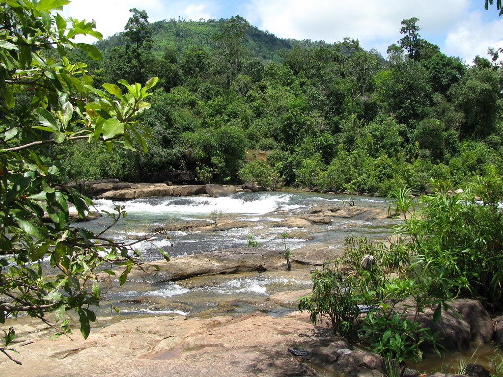
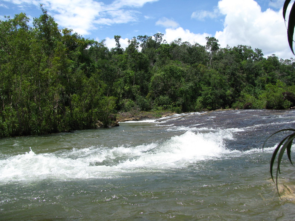
What more is there to add? Not much. Visited in August 2008, it was quite deserted, though the amounts of refuse along the path down to the bottom of the falls were ample evidence that on some days (weekend?) more people visit. No possibility for soaking around, the water thunders down. A spectacular falls, nonetheless.

Natural beauty


Apparently Bou Sra Falls, Mondulkiri are Cambodia's most famous / most spectacular. Visited in April 2006 I was impressed by the falls. Only I was more impressed (or depressed?) with the quite literally hordes of visitors. And the way they trash the place. Natural beauty no more.

Let's trash the place

Bou Sra waterfalls are 43 km from Sen Monorom, Mondulkiri province's headquarters. The latter half of the trip goes over a toll road, which is actually a piece of improved track. Funny how you can ask toll for this. There is a big car park behind the entrance ticket sales place. Elephants are also parked here and you can take a 5 minute tour of the parking area on elephant back, Heading towards the falls, there are a large number of stalls selling basically what ever. The entrance track ends on a plateau of the waterfall proper, upstream a 15 m fall, downstream a 20 m fall. On this plateau is ample space to consume whatever one had just bought, which seems the major past time.

So enough to snack on, lodging? One of Cambodia's best, the Nature Lodge is located in Sen Monorom.

A full description:
'Bou Sra waterfall is located in Pich Chenda district about 43 kilometers northeast of Mondulkiri provincial town, Sen Monorom. Busra is considered by many to be the most beautiful waterfall in Mondulkiri. The waterfall is divided into three stages:
  • First Stage: The waterfall fall is 8 to 12 meters high and 15 meters wide in rainy season and 10 to 15 meters wide in dry season.
  • Second Stage: The waterfall fall is 15 to 20 meters high and 20 meters wide in rainy season and 18 to 25 meters high and 13 meters wide in dry season. The second stage is 150 meters from the first stage.
  • Third Stage: The speed of waterfall is faster than the second stage. This stage cannot be reached because it is in the thick forest. There are no marked paths and dangerous wildlife inhabits the area'.
The second stage

Since there has been suggestion that the waterfalls will become a eco-tourism site. What that entails:
'A local Cambodian group, Sar Lar, has plans to develop a US$6m resort around this waterfall to entice more tourists to the isolated province. It has a 99 year lease from the government to build motels, restaurants, souvenir shops, cable cars and cottages. It has assured nearby villagers that the 5 year project will not be disruptive to the environment as no forests are to be cut down for the development'.
Well, that certainly will enhance the area.
Some have their doubts:
'don't sound altogether eco-friendly to me'.
Well but is it worth it? Well, the falls are certainly spectacular, just avoid holidays and weekends. Also don't count on natural beauty.

Ethnic Chic?
Possibly.
Just another gimmick for tourists: dress up as a local (used to).

Tuesday, October 20, 2009

Washed out

Like the previous posting, everything seems better in the past. This also applies to this waterfall near Pai township in the northern tip of Thailand near the Burmese border.

Pai itself is a very relexed place to stay, a broad valley surrounded by mountains. The inhabitants of this valley are many different hill tribes giving each village a different feel. The river passing Pai flows gently. Traffic is slow and far between, it's off-the-track a bit. There's not much to do, a waterfall here, a hot spring there, some cycling, walking and possibly rafting. Just a place to soak up the atmosphere.

Anyway Mo Paeng (or Mor Pang) was apparently a beautiful waterfall located in the forests west of Pai town. However a flash flood in 2005 stripped the banks of the forest cover. That does not mean that the waterfall is not worth a visit. It is.

It consists of a number of steps possibly added together to 50 m height, each step 5-10m. The water flows over flat smooth rocks and are great for sliding.


Located about 10 km from Pai, it's a nice bike ride, though it's uphill struggle, good for going back and this way you work up a sweat which makes the falls and pools more enticing! It's past the last village, there's a sort of a parking area from where you follow an irrigation ditch for 200 m. I suppose it can get very busy, but when we visited (2006) it was far from that, even so quiet to allow for a family member to go au-naturel.

There are no facilities, though a Shan village nearby has some shops. Accomodation is to be had in Pai town itself, which is far outpost of mae Hoing Son province. There is a good if winding road to Chiang Mai.


Charming

Ko Chang is always the next big thing in Thailand. Not a thought that it could be a thing of it's own. One problem it has in meeting the ticket, is that the island is very mountainous rendering inter-island travel difficult. There are only steep and narrow roads bringing you from one beach to the other.

However the mountains could also have been their saving grace and given Ko Chang a charm of it's own. Still heavily forested and located in a part of Thailand which has just a brief dry season, rivers flow year long. Or was that in past tense? Most water is required by the seaside resorts which offer only that, the sea.

The interior is ostensibly a national park. The main reason is possibly to shake tourists 200 THB for the privilege of seeing a half dried up Khlong Phlu waterfall. Visited in 2005 the dry had already set in. Possibly it might be a delight during the wet season.

Accessible from Ao Khlong Phrao beach a sealed road leads to the ticket counter and tourist trinkets mall. A 500m track heads on to the bottom of the falls. A great looking pool lies beneath the 30-40 m fall, but I was not so interested . Just for the photo op. then again on the web there seem many contended tourists, it's just might be what you expect ....


More info on waterfalls on Koh Chang can be found from this website.

Exotic

The name of these falls, Tat Xe condures up images of the exotic, though it's probably just the use of the X in the name which assists this process. However none the less, Tat Xe are a special place. Located not far from Luang Prabang town, Lao, the water drops over a wide area in small steps between pools. On the edges of pools trees grow giving it the sphere of a flooded forest. The water is fresh and cooling, even in summer.

Getting here, means going east for 10 km, taking a track to the river, climbing aboard a boat for a 5 minute downstream boat ride. The falls are then a 2 minute walk on the other bank of the river. You pass a entry gate where a small entrance fee is required. Accommodation is not available nearby, but all-in-all it takes 45 minutes from Luang Prabang to here.
Drinks and noodles though are available and there is a flat sunning area, with steps to a larger pool. It is also a very clean area.

Many tourists visit here, but mostly at the end of the day. Come before lunch and you have the whole place to your own. It's a great place to while away your day. I have visited here a couple of times, in 2004/2005. Since then tourism has been booming in Luang Prabang and you can now probably expect a whole circus to turn up. Well not really but elephant rides now also take place to the falls.


Less exotic spelling exists Tat Se or Tat Sae, adaptions to make it easy for foreigners, the last even being the more used. You can exchange the second T for a d and still make sense.

Rainbows


Many tourists come to the central Thai province of Sukhothai to visit it's hundreds of years old ruins. However the province also has two beautiful national parks, one of which is
Ramkhamhaeng. Besides a high plateau there are a number of waterfalls around the base, one of which is Sai Rung or Sairung, which translates as Rainbow.

A very common name to give to a waterfall, there are many Sai Rung waterfalls around Thailand. All have as common features a high fall with little flow such that with the sunlight a rainbow appears.

Visited in October 2008, this waterfall is located on the southwestern edge of the national park, a few km off highway 1331 which bisects the park on the west. A turn off leads to a national park entrance and a car park. Again ample evidence of times when the park would be packed, but when we there, not so many were recreating. A steep path leads up and along the stream with many smaller falls and pools such as depicted above but the ultimate goal is the bottom of the 100m drop of which I have no picture. Darn!

Not many facilities available. Sukhothai itself is about 50 km away. Kamphaeng Phet about the same. Inbetween the park and Kamphaeng Phet is a hot spring Phra Ruang, worth a visit.

Getting There

Thmor Roong (or alternatively Thmor Rung) is a series of rapids and shorter falls over a 500 meter stretch of river in O'Bak Rotes commune, Koh Kong province, Cambodia. Nothing actually distinguishes them, other than their unknownness.

Efforts have been made to set up a few stalls where the entrance track ends, though these are only manned during Cambodia's major festive days. Arrive outside of these days the place is deserted. Near the entrance is the highest falls though it's much more of a slide than a fall. Head upstream and there are many more water holes and rapids. Not all deep but enough to paddle about in.

Access was poor (2008) and since, the access has become worse. The access road starts from National Highway 4 (Phnom Penh - Sihanoukville) just beyond the second (new) toll booth, about half way. The road veers off to the west. This stretch has a number of potholes and a long rickety wooden bridge. At the T-crossing (a km from the turn-off) one goes left and continues beyond the village. There are a number of muddy sections and close to the end one should pass through a stream. This last September (2009), it was only passable with 4 wheel drive vehicles. In all it is only 3-4 km from the highway, sufficient deterrent to avert the easy-going crowds, but enough to assist those more intent tourists.
Some of the rapids upstream

The main falls area during rainy season
Just veer of the path and have your own dip

And in the dry season ....

An update from 2010.
Related Posts with Thumbnails