Thursday, December 1, 2011

Gem hunting

Khao Lak, north of Phuket, Thailand, seems to be well-known for it’s coast line, but surprisingly the coast is haphazardly developed to the extent that development kills the exact source of it's charm. Sure there are signature resorts, but outside of this, the tourist ghetto’s are over optimistically hoping to cash on the non-existent tourist. Maybe in some times of the year, the plethora of rooms are full and the trade for suits infinitive, but otherwise it’s all dread and drudgery, alas.

So why the trade has failed to see the gems within eyesight is a mystery? Khao Lak’s coast has a series of waterfalls just beyond the main drag with it’s line of tourist business.

At the northern end, you’ll be able to visit the easily accessible Bor Hin waterfall. Just north beyond the Royal Bangsak Resort, look for the huge school on the mountain side of the road and take the first turn inland. The small road winds itself through rubber and palmoil plantations and ends after 2 km directly at the foot of the falls.
In front of you, you can see the waterwall, with a number of channels, the water sliding down about 20m. It seems to have seen better times, management is non-existent, despite it being a nice location. Some refuse has gone awol, but is not an eyesore.

Along the roadside a track takes you to the top of the falls. Possibly going even higher would bring one to more falls and / or swimming holes, but as it was rainy season, the rocks were particularly slippery.Bor Hin definitely does not see many tourists and info on the internet is scarce. In fact there is hardly anything beyond the odd mention. Gran moskys has an entry on waterfalls on the Khao Lak coast reachable by bicycle.

Thursday, November 3, 2011

Plunge jacuzzi

View from the old road

Ease of access is key to most Thai waterfalls, but seldom is access so guaranteed as to Punyaban (or NamTok SetTakuat, source) which falls nearly onto highway 4, just north of Ranong town.

In the sharp U shaped turn, the old bridge and both banks are used to create a park like area with the 50 m waterfall as natural backdrop. Near the parking areas are two small restaurants as well as amenities block (or two). One can walk below to the stream level and safely go up to the base of the waterfall.


Strongly recommended is to take the nature trail path on the north side. Steep, it’s well laid, though not often utilized. The educative element has slightly became a victim of time, the trail itself climbs beyond the lip to a smaller fall and beyond this to a 10 m fall.

View towards Myanmar

With a beautiful view as well as the solitude gained so close to the mad world as represented by a major highway, this area above the larger waterfall entices one to become one with nature and plunge in the natural rock jacuzzi’s or get immersed under the falls them selves.

Up beyond the main waterfall are some great skinny dip pools.

More info can be obtained from cathy and gary's travel page entry on Punyaban. Note that the waterfall i s just 10 minutes drive north of Ranong town, it counts 3 levels but only 20m height. Their end note:
'Punyaban Waterfall - Beautiful Place'
Others mention the nature trail heads back down on the other side.

Lonely Planet rates Punyaban as no. 5 of the 11 things to do in Ranong.

Interestingly the blog waterfallsonstamps names Punyaban as one of his 9 stamps of waterfalls from Thailand (from 1980, 2 THB!).

Anyway, Punyaban is definitely a contender for top 10 waterfall position in Thailand.

Just one of the pools waiting for you to quit your sweaty clothes!

Sunday, October 2, 2011

Rainbow splashes

Such is life. There's hardly anything of notice at Chum Saeng waterfall, but still the 3-legged dog wandered down the road for 200m just in case.

A great road for waterfall hunting is the road between Chumphon and Ranong, especially on the Ranong side of the water divide.

Chum Saeng waterfall is the first signposted waterfall along the way, km's from the main highway interchange 80 km's before Ranong. It's on the south side of the road near km's 529/530. The waterfall is only 3,5 km from the main road.

The local roads department have foreseen larger things for Chum Saeng and have built a two lane highway from the main highway straight to the foot of the falls. Nothing has been left to coincidence and a once beautiful park-like surroundings would have existed. Not anymore unfortunately, as maintenance has failed to keep up with visitors resulting in a under utilization of the site as well as the slow accumulation of refuse making it increasingly desolate location.

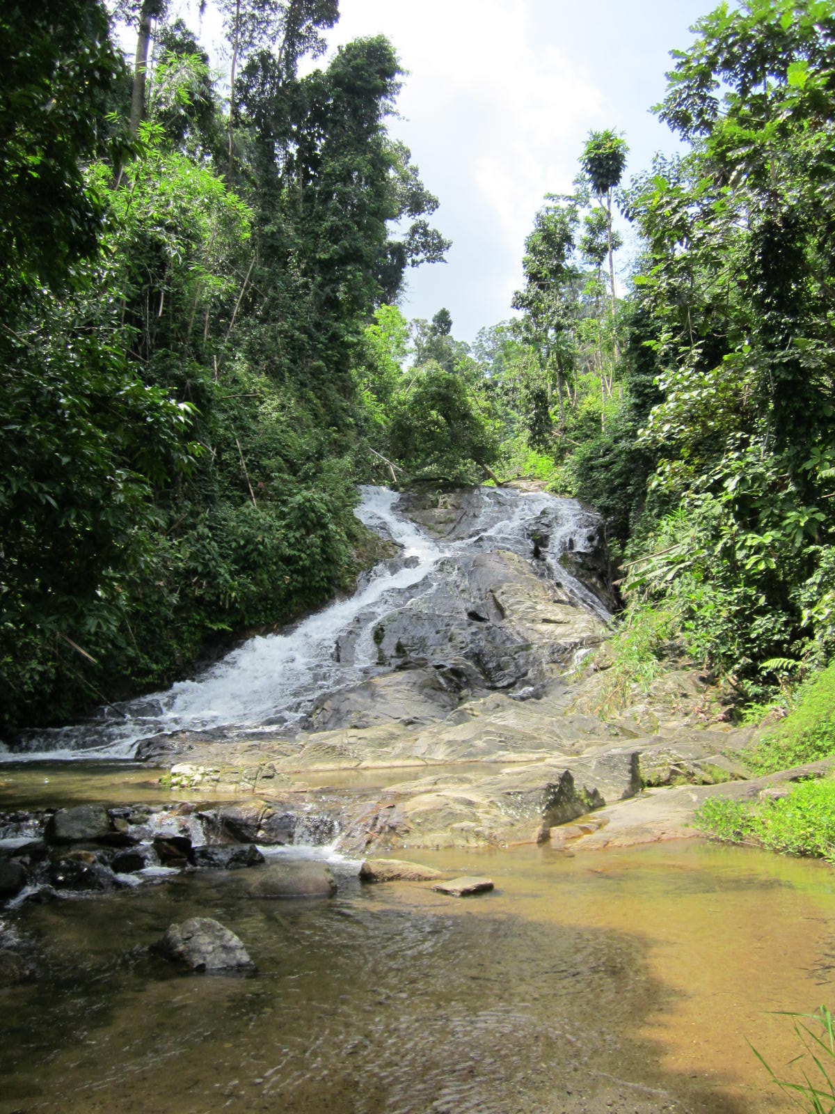
It’s a nice view though, 50m or so of the fall. Further back the view is more impressive than being just underneath the fall.

RideAsia.net have gps coordinates (N10.30.030 E098.53.029) though they also mention there was no water in the falls during the dry season. Wikipedia adds:

'In the rainy season, a lot of water cascades down the boulders in rainbow splashes. This is how it is called “Namtok Sai Rung” or Rainbow Waterfall'.
No rainbows in the dry season!

No quite a rainbow yet.

Thai-tour.com adds:
'Sai Rung which means a rainbow in named according to the splashing figure of the waterfall resulting from the strong hit of the powerful water agains rocks'.

Friday, September 2, 2011

Of mannequins and monks


Sometimes you come across a waterfall with a difference. Huai Yang waterfall has something different. Namesake for the surrounding National Park (meaning the requirement for a 100 THB entry fee ...), it's obvious it sees huge numbers of visitors, based on the well paved car park. 

Despite this being a weekday, a few cars are pulled in and on the opposite side of the creek is a huge huddle of white clad students acting as if they are listening solemnly to some speech or another.

Unfortunately, just when we hit the track so does the group and swamped by white shirts (which political direction do they support?) we climb up the track. It's a nice climb, once in front of the group.


Keeping ahead and looking behind: level 3.

Up on the ridge one gets to a small shrine. Beyond is a big pond at the foot of a slender fall, the third level of five. Possibly already wearied down tourists are hanging around. But there are more levels to explore. One can jump over rocks to the other side, followed by a scramble over bare rocks. The stream equally forces it's way down over mostly short scrambles. We reach the next level, a delicious pool with a great 15 m fall on the opposite end.

Oddly enough a monk is here, feeding the fish (see lead photo, above), mostly catfish and carpers, largely ornamental varieties. It's a disturbing trend in the maintenance of what are essentially national parks, rearing fish, so as enhance something or another. The more frequented waterfalls of Thailand (read Erawan, Pa La U) seem to be teeming with fish and considering the regular feed supply, it's no wonder.

My son vehemently opposes any swimming with any fish, while my wife decides that it's not her day. I wait for the monk to totter off, undress (that's me) and enjoy another spectacular part of Thailand's nature. Meanwhile  praying the fish won't nibble my special parts ...

Alex has a number of photo's, but other than that there is not much than the obvious reference on how to get here: located in Prachuap Khiri Khan province, the waterfall is conveniently accessible from the major highway south (km 350), only a 7 km ride to the foot of the mountains.  

There's panaramio.  

And travelfish.

Ursula's weekly wanderings has an interesting entry on the spirits of Prachuap Khiri Khan including some photo's which really are weird kind of spirits (mannequins?) which are to be found near the shrine at the first level.

Sunday, August 7, 2011

Stacks


The lowest level seen from above

The details:
'This waterfall is located at km. 556-557 on highway No. 4 3 kms. from Kra Buri township with another 13 kms. on the leftside of the main road along the laterite road to the fall. Bokkrai Waterfall has many steps with fascinating nature surrounding'. source

Bokkrai, Bok Krai or Bok Kray. Sounds and looks pretty clear and this time around, it is clear. The road makes it all the way to Thungraya - Nasak wildlife sanctuary's entrance, another protected area along the spine of Thailand, straggling Burma or the Andaman coast. After we pay the 100 THB entrance fee (~$3) and receive a stack of tickets in exchange (good deal, 30 tickets of 10 THB instead of just the normal 3 of 100 THB), we proceed to the deserted car park just beyond the entrance.

Ranong's landscape is nice and lush, the minor road up to the sanctuary entrance winds it's way through mostly rubber plantations with the odd oil palm plantation thrown in for reasons of variation.


>Anyway once in the sanctuary, the bush is still lush but more lustrous. Quite wet, a good track goes to the namesake waterfall, only 200m away.

Bok Krai, the main lower level.

There one learns that there are more levels, 7 no less and we take the good looking track up. However the higher one climbs the more muddy and less maintained the track becomes, like having to fight oneself through a jungle.

But, what a beautiful place. Well deserted with some the gracious pools. I hate to disturb the free flowing nature with my own natural antics but why else come all the way from the modern world if not to merge with the natura?


Sorry for the disturbance!

Elsewhere on the net are another blog entrance as well as some more photo's by nobythai.

Tuesday, July 19, 2011

All relax


Thailand's southern province of Chumphon is not well known touristically, not for it's superb beaches, nor for the beautiful forests containing possibly some great waterfalls.

That said there's not a tourist website that fails to mention the existence of Kapo (Kapoh) waterfalls, to the northwest of the province's capital.


Though why this figures as the most mentioned of this province's waterfalls beats me.

The waterfall is easily accessible from the main highway (no. 4) going south via a very poorly signposted trail. Blink and miss.
The access road brings you to a grassy plateau, none of which might give you a clue that you had arrived already. Continue onwards the black top runs out and you end up on a T crossing. Way too far!
The waterfall is near the grass plateau, travel back. Park the car and visit the hardly discernible waterfall.


Apparently somewhere in the past, much effort had been invested in making this a recreation park, but no funding reserved for maintenance.

The 'fall' is a 2 m drop followed by a couple of short drops into a stagnant pool.
Due to the fact that this waterfall is near to the highway the effort to pull the car over from chugging down the highway is quite easy. But expectations should be tempered, maybe stock up at a petrol station and have a picnic.

Most web sites refer as follows:
'Located in Tambon Salui, this waterfall is 13 kilometres from Tha Sae, along Phetkasem Road, between 466th 468th kilometre, or from Pathomphon Crossroad, by Petkasem Road for about 30 kilometres. The park has the area of 7,010 Rai of shaded forests and small waterfalls, suitable for relaxation' (source).
The Bangkok Post adds:
'It is a pleasing dappled park with a small waterfall and many species of plants appropriate for natural science study and relaxation'.
Kohtaotoday puts the following description:
'The park has a pleasant atmosphere of cool forest with a small waterfall flowing. All year round. There are many kinds of the plants, the residents of some birds kinds of the animals. This park is suit able for relaxation'.
Downstream

Sunday, July 10, 2011

Deadly

Khao Sok National Park is a funny kind of place. Due to it's relative proximity to Phuket / Khao Lak, the ability to use it as a stopover from these places to / from Samui ferry and being just one km from a nice highway, it see's it's fair share of tourists. So much so, that a village of lodges, minimarts, travel agencies and cafe's / restaurants has sprung up.

Besides the facts of access, the reasons for a visit include the entrance point to one of Thailand's biggest and most spectacular national parks, the impressive craggy scenery and deliteful meandering stream that finds it's way through the various bungalow operations.
A poorly translated blog site names Khao Sok as no. 2 in Thailands list of top 10 national parks.

An acquaintance with the steamy jungle is on the cards.
Khao Sok offers a number of trails, along some streams. Having done these trails already 20 years back, one would expect some improvement. But none of that. Though the village has expanded exponentially, the national park has little to show for 20 years of high entrance paying tourists. One is still leant on to take a guide to destinations just beyond a ninety minute walk over a 4WD track. Going beyond is forbidden without a guide, at least in the wetter half of the year. Such is the pressure that even to this point of return groups of tourists see themselves compelled to hire a guide which is ridiculous.

Though I might see some safety element in this, it questions why the same practice does not take place elders. Or why simply the trails are made safe enough for independent tourists. But maybe keeping the guide trade in business trumps all other reasons.


Anyway, mid 2011, we took the walk up the Khlong Sok as far as possible which leads to amongst a couple of swimming holes, the waterfall of Wang Hin. Wang Hin sits on a small tributary on the opposite bank of the main Khlong.

Beyond the Khlong, Wang Hin waterfall.

Further upstream are the waterfalls of Bang Leiap Nam and Ton Kloi, as well as Than Sawan which is up a side stream. Possibly a guide might be required for this waterfall

From the national park headquarters there is also the possibility to visit Sip-et-Chan waterfall, an eleven tiered waterfall (the translation already says it all). Possibly reachable during the dry season.

Other trekking destinations are the already aforementioned swimming hole
(see photo of Bang Hua Raet below) as well as a few more spots for a dip.

Me, getting more wet with water than the customary sweat.

Just outside the national park there is the possibility for tubing (with guide), canoeing (with guide) or elephant trekking.

Over the mountains is the exceptional experience of where a major stream in the park has been flooded for hydropower usage. The lake level has risen enabling boot journeys around and among the towering limestone cliffs, a must-see.

The lake on a rainy monsoonal morning.

Wang Hin waterfall of Khao Sok National Park is located in Surat Thani province, just over 100 km due west along the main 401 highway. Good and recent info on the park is available from Khaosok.com as well as from Khaosokdiscovery.com.

Probably some of the best independent users information comes from Tezza's beaches and islands extensive and updated entry on Khao Sok. He goes to considerable lengths to warn against leeches, I had only the one after 3 hours, which dropped off by itself and the bleeding terminated after a couple of hours.

The leeches contribute to Khao Sok being rated as the one of the
World's Deadliest Places to Swim!
'Before you go camping in this national park, be advised. The area is the home to more deadly creatures than any naive tourist can imagine. Huge centipedes the size of an adult man’s arm, man eating sharks[!, there are none!], blood sucking leeches, giant mosquitoes and poisonous caterpillars and Scorpion fish. Getting bitten by leeches is seemingly unavoidable so make sure to take up smoking as leeches hate tobacco. When attacked, mix water with tobacco and pour it over the leech and it should let go. Whatever you do, do not try and remove it by force as it will cause it to release its venom'.
A better perspective to be had is from Thom Henley's Waterfalls and Gibbon Calls (2005).

Wednesday, May 18, 2011

Barking up a tree

Ahh, another spelling mischief. Sap Chomphu, Sub Chom Phu, Subchom Poo, pronounciation same-same, just too difficult to spell ...

Anyway, another Phetchabun province waterfall. Not located in a national park, administratively it is seen as an arboretum with waterfall. Or a National Forest Reserve.
Barely 30 ha in size.

Getting here is not too difficult, located 8 km south of Nong Phai on highway 21, the access road is from the village market, due west. Just slow down in the village and take the only road west, once on this road there are signs virtually every km, for the 8-9 km it takes to get here.

The road gradually rises as it dissects mango orchards. Late April, the farmers are up early and the road is used as collection unit for the plastic containers full of mangoes, waiting for transport to Bangkok undoubtedly.
Despite all the signs along the way, the last one directing you to take a right before the steep incline is non-existent. On this cross road though is a wooden sign which describes this as Sap Chom Phu Arboretum.

Past a few houses one enters along a now empty pond. Behind this are lined a serious amount of stalls and an expansive parking area.
No entrance fee is required and one wanders across the bridge. Not many foreigners get this far. This I conclude as the number 1 tell-tale sign, a pack of dogs is barking at the exotic creature (must be a ghost), is all too clear. From beyond the bridge there are a number of trails heading up and I just take one.

Within 2 minutes I am walking alongside a small stream (Sai Ngam Ngam) under huge trees, the trees alone are worth a visit. Some larger examples have been singled out for the yellow ribbon worship.

However the stream itself is a trickle and despite walking as far as possible, the waterfall is only a number of short steps.
Possibly these are part of the three waterfalls mentioned as per Bangkok Post.

Waiting for the rain(s)

It's evident that later on, in the rainy season, there are much bigger falls to be experienced, see the picture of a full size poster at the entrance of the falls (below); despite an overnite downpour there's little to be seen, let alone experienced.

My photo's posted here are quite similar to those of the Bangkok Post referenced above, in the absence of the big waterfall.

What it should look like

In all it seems a little depressing as extensive amounts of trash take the shine off the naturalness of the surroundings. Better management might be an idea ...


More photo's from this provincial
blog.

Monday, May 9, 2011

Cement


Saraburi is to most who pass through this province, synonymous with traffic, cement factories and huge Bhuddha's; certainly not with nature.

But surprise, surprise, Saraburi province, despite it's size, contains no less than 2 national parks,
Namtok Chet Sao Noi and Phra Phutthachai (sometimes known as Khao Sam Lan). Furthermore there are quite a few waterfalls, some more well known than others. Muak Lek waterfall (tiny), Heo Noi, Sap Heo, Suan Maduea, Sap Pa Wan, Krok Fa Phanang and Khao Khaep.

Dried up
As Khao Sam Lan National Park is listed as having a signature waterfall (Sam Lan) as well as some others (Pho Hin Dat, Ton Rak Sai, Krok I-woe, Nang Chon, Phaeng Ma and Roi Kueak Ma) and it's just outside town towards Bangkok (take road 3042, followed by 3046), it was the destination of the late April day.

Fancy coming up to the entrance and being told that the waterfall was dry. They basically implied that the 200 THB (~$US 6) special entrance fee for foreigners was not worth the sights located further up the road.
Many locals continued but it was said that they were going for the food stalls and to relax, as they don't seem to have to pay an entrance fee.


Oh well better this way than the other way around. Expect much more water later on in the year.

[Update: The Bangkok Post (1 September 2011) places an article on the Sam Lan NP suggesting it is better to negotiate the park by cycle:
'Being the Kingdom’s smallest national park, Namtok Sam Lan NP of Sara Buri province covers an area of only 44.5 square kilometres. It is named after a waterfall that is known to be dry and lifeless most of the year, except on days that it rains real, real hard'.
Hmm ...

Next stop
I took a long and hard look at the map and decided that Chet Khot (Chetkhot, Jedkot?) waterfall would be do-able, not too far away. I double checked at the national park entrance and they said, yes, expect more water there. Fine.


So eventually back on route 2, in the plethora of traffic. Past cement factories heading to the giant Bhuddha. Ideally you want to turn off in Thap Kwang village, just before the highway starts to rise into the hills. But hey, this is an 8 lane highway, don't do the U-turn, just travel up beyond the next cement factory and there there is a fine overhead U-turn, safety wise better and loads more comfortable than sweating it out while waiting for a break in traffic.

Back in Thap Kwang head left and ask around. Eventually you'll end up on the right road which goes up into the hills for another 10 km or so. Winding itself around and over the hills it passes some smaller villages with small plantations. Signage is clear from here.

Surprisingly despite it's proximity to Bangkok there's little touristic development. Eventually the road ends at a car park, a couple of other cars and about 20 or so motorcycles, no entrance fee is required.


Upstream
There are a couple of buildings around the car park, overlooking a series a small rapids.

On the other side of the stream, a track disappears into the forest. It's a 1,5 km track which traverses the stream about halfway. At the end is brilliant pool with about a 10m high waterfall.

Young lads (owners of the motorcycles) are jumping off the cliff and generally seeking some kind of attention. A beautiful spot, but even on a Tuesday too spoilt by my fellow humans.


I walk up the side of the cliff, our youngsters expecting me to jump as well, but no (thank you), I just continue up the stream. There's no path but wading through the stream and scrambling over the rocks, brings more sought-after solitude, another beautiful spot.

Around
I hope it stays like this, my map also has a dotted red line crossing closeby the falls, the motorway no. 6 project. Yikes!


There is surprising amounts of info available on Chet Khot especially as somewhere nearby there's a nature study center (or here) located which arranges treks to more waterfalls in the area; Chet Khot Nue, Chet Khot Klang, Chet Khot Tai, Chet Khot Yai, Khao Raet (or Khao Khaep?), Krop Fa Phanang and Krok I Dok.
Andy has stayed overnite. Wow.

There's an article from the Bangkok Post (September 2006) about a visit here, including his or her experiences while trekking to Krok E-Dok waterfall, 8-10 kms from the center, but surprisingly under two hours of walk!

Kitaro has a photo overview of Klong Pakkham in Chet Khot forest.

Well, now I know Bangkokians have no reason not to escape town ...

Monday, May 2, 2011

Horn-billing


Phetchabun province is just over 4 hours easy drive from Bangkok, but it's a great place to visit which (despite it's proximity) still receives next to no tourist; even Lonely Planet doesn't mention this beautiful province!

In essence, Phetchabun province is a wide north-south valley, crammed between at first hills, later on 1000+ m, so no wonder that waterfalls are a major feature, though surprisingly scarcely visited.

One of the lesser known national parks in Phetchabun is that of Tat Mok, considering that the province also contains the Hin Rong Kla national park. The 290 square km Tat Mok National Park is named after it's signature waterfall which is said to be a 1-level 200-300m high waterfall

Getting here is not too difficult, from Phetchabun town head southeast and take road no. 2271 until it reaches road 2275. A right turn is required and then quite quickly the entrance to the park will need a left turn. From the entrance it is 18 km over a mountainous road to the road head.

Not many foreigners make it this far up-country and after the ticket lady contains her surprise thereafter followed a frantic scram (involving 4 staff members) to find the correct 200B entrance tickets, nearly 7 $US (April 2011).


It takes about half an hour to drive the deserted road to it's ultimate destination. Going up there are two larger viewpoints, if clear one could easily see Phetchabun town. After the first hill there are some more offices and a campground, beyond seems to receive even less visitors. At a certain moment I need to get out and remove a large branch from the otherwise good road. The valley gets more narrower and ends at a small car park with some amenities, but no one seems to be hanging around on a late Monday afternoon.

The track then starts and should last for nearly 3 km, 45 minutes. It's not often that in Thailand there are long walks possible (Thai's prefer drive-in nature) and certainly not well signposted ones. The trail hugs either side of the stream and has seen better times. On narrower sections, the improved pathway has been washed away as do all bridges. Attempts have been made to keep the track passable and it really is a nice beautiful walk.

An improvised bridge

Finally one comes to a section where the trail splits, the lower path continues onward for another 200m to the Song Nang waterfall (or Songnang)whereas the higher steps should take you to Tat Mok.

As rain is threatening with clear intentions of today's daylight being curtailed, I skip the Tat Mok part, as it is a high waterfall but with little water.

Instead the Song Nang waterfall is in front of me. It's a 10 level waterfall with delicious pools to skin dip in, yeah!


Author chillin

After chilling out it's time to return, drops of rain are falling. The best part of this is that birdlife are welcoming the moist and are out in numbers, audible though not visible. A salvo of larger cries leads me to believe that horn-bills are overhead and low and behold at an opening I see no less than 10 juveniles frolicking in the tree tops.

Back at the end of the road, there is still a great place to rinse off the return sweat before returning to civilization.


There are a couple of web sites on Tat Mok, mostly poorly translated from Thai, resulting in a load of gibberish, see for instance
'Tat Mok - two waterfalls her'.
sbayura.com has a good posting on Tat Mok / Song Nang including extensive photo's.
Thaiways has a picture of level 6.

Nearby is the hot spring of Nam Rong, possible as a post walk soak.

Thursday, April 28, 2011

By Bhuddha


Intro
Signs say it's Wang Kan Lueng, others prefer Wang Kan Lueang whereas Wang Kan Luang seems to result in the most finds.


Probably Lopburi (Thailand) province's only waterfall, it will come to a surprise to many that there is even a waterfall in this mainly flat province. Better known for it's sunflower fields, the surrounding rolling hills are packed with to be planted cassava and/or to be harvested sugarcane; there's little to suggest in the geology nor in the landscape that hidden between the fields are a beautiful series of cascades.

Accessed from road 2089, Muak Lek - Chai Badan, entry is about 7 km north of the intersection with 2256 and the town of Tha Luang. The entry road heads west towards the floodplains formed by the Pa Sak Jolasid Dam. Only a km in length and extending on both sides of the stream, one soon arrives at the entrance proper: a car park with an impressive amount of food and knick-knack stalls.

Bhuddha
Effort has been made to keep the surroundings attractive, despite the lack of official protection by forest or national park administration; more often than not the way waterfalls are protected in Thailand.

Part of these efforts are directed by the erecting of a number of Buddha statues, Pae and Guy have a small blog entry solely on these statues.

All lined up

Exploitation
Officially described as an arboretum, there's not much to suggest that this is really the case. Just above the falls, a bridge extends to the other side which also has a large car park with vending stalls. Walk down stream past the main part of the falls and there is yet again a large bridge so one can make a circular route around the falls.


Gazing down

The main part of the falls are a rocky drop of about 5m. It's obvious that the underlying rock contains large amounts of calcium and the water changes colour to white/grey.

Above the falls are a number of vendors renting out picnic mats and inner tubes and judging by the height of the stacks, on certain days there must be heaps of visitors, Bangkok only 2,5 hours away. Above the falls are also some ponds to splash around in.

Betting on tubing

Below the falls, waters continue to drop creating small pools as the stream jumps in half meter / meter intervals. This section of the falls is impeccably clean and well-managed.

Further away
Downstream of the fall proper, extends a nature walk, hugging the north side of the stream. In places the stream becomes stagnant, but beyond the nearest stagnant section the stream continues it's jumping pattern. On a Monday morning there are some families near the main section of the falls, but at this time further downstream it's totally deserted. More worrying though is that refuse management does not extend this far and there is quite a bit of wind blown rubbish to be observed. The natural habitat evaporates and up to the edge of the stream are teak plantations. However each stream fall is followed by a waterhole, just the place for a secluded dip.


Web
Internet gives some other experiences, though most are positive. Paul Garrigan, a Lopburi located blogger, is quite surprised his province heralds a waterfall and despite his possible misgivings is quite impressed:
'When I caught my first glimpse of Wang Kan Lueang I was impressed straight away. I am no stranger to waterfalls in Thailand; for five years I lived in a village that is situated around a stunning ten level waterfall. Once we descended down some steps to Wang Kan Lueang it turned out to be a lot more crowded than I was expecting; I automatically regretted not bringing my swimming trunks because the water looked great and there were quite a few people already having fun'.
Melissa Swenson has a few pics from an equally good time. On flickr there are parts of sets by Joel Oh and lucaskt.

Tuesday, April 19, 2011

Updates

It's probably the first time I have used this blog for updates. Usually if there are updates I add them to the postings, keeping everything much more current.

However, it's not common for waterfalls to make news headlines and unfortunately it's mostly for the wrong reasons.
From
addyjagat an extensive article on the death of a British women who fell down 100m on the Ton Nga Chang waterfall, 25 km from Hat Yai, southern Thailand.
'... slid about 30ft down the sloping rock-face before plunging off the steep 300ft drop'.
We tend to forget that waterfalls can be dangerous and the above is just another wake-up call. No doubt the authorities will come with extensive measures to avoid this happening in the future, though warning people always seems to be the most sensible.

Horrific and tragic.

Other news worth mentioning is that travelfish blogs are getting entries on waterfall hunting around Chiang Mai, up to now two great entries.

Monday, April 4, 2011

Past the bear pit


Part of the Yang Bay Tourist Park complex or at least just outside the most developed part of this tourist development complex, Ho Cho waterfall is a wide low waterfall, in all descending 6-8 m. I guess. Below is a great pool where one can take a very undisturbed swim. At least during the week, when visitors are few and far between.

That's for now. It's quite strange, this lack of even a decent track, slam-bam next to Yang Bay Tourist Park. Instead of going to Yang Bay waterfall itself, once inside the 'park' one takes the left road past the bear pit, tribal game place and orchid garden. Abruptly the wide road stops (10 minutes after taking the road) at a wild stream.

A small path continues through the high grass to the river where a small log has been laid over the first 2 m of the river crossing; the rest can be achieved by jumping from rock to rock. On the other bank of the river, the track continues through the forest until it hits the rock-face of the waterfall itself. No track beyond this by the look of it. Time for a dip.


The Yang Bay Tourist Park companies brochure describes Ho Cho as follows:
‘To be deep in the forest. Ho-Cho waterfall is considered as a challenge to visitors. Ho-Cho waterfall also owns a lot of hot mineral water sources helpful for cure’.
Well, the effort required can not be described as a challenge, it is pretty easy. I'm unsure about the hot spring claim though, it certainly was not apparent.

Another link to the possibility of there being mineral water is here:
'After a refreshing dip, visitors can relax in a natural hot spring'.
As stated in the Waterfalls of Southeast Asia blog entry on Yang Bay, management may want to expand the mineral water on offer and add in some mud (as in the success of Thap Ba hot spring).

It's a pity that not much is made of the current mineral water facilities, if existing.

Despite the development, Yang bay and certainly Ho Cho are worth the effort.

Update [June 2012]
This article mentions 
'The waterfall [Ho Cho] includes two streams, one hot and one cold. If tourists fancy having fun in the hot water or just want to relax, the park management board has built a swimming pool, which mixes the two streams of hot and cold water.
The waterfall will soon be developed into a hot spring site'.
All part of an expansion ...

Monday, March 28, 2011

Tax man. Not.


It's not often that a waterfall is included in this blog which I didn't go myself, in fact this is a first.
My wife was in Cambodia's western province of
Pailin, not a place often visited. There she visited the Olavao waterfall, on her way back from Pailin.

There's some confusion on the name.
Travelfish notes it as Otavao:
'If you're going to spend the day in Pailin, Otavao Waterfall is the area's top attraction. It's an easy trek to the top with several different sets of stairs along the way that lead down to the falls.
An unnamed restaurant is at the top and offers Khmer food and cold drinks. It's a great place to rest as it overlooks the falls and offers marvellous views of the surrounding lush scenery.
Several canopies are dotted along the falls and serve as good spots for resting or a picnic. It's best visited during rainy season, but either way, you'll likely have the site to yourself'.
O Tavauv is what the falls are according to Zepp (2):
'The falls are privately owned, by none other than I Chien, govenor of Pailin and son of Ieng Sary. This is not a National Park, and is yet another example of the Cambodian elite using their official position to further enrich themselves. And yet, they are performing a public service. It is the same system that cannot collect taxes for education but which gives you Hun Sen schools'.
Zepp goes to say that there are in fact seven falls.

This website mentions O'Tavoa.


Matt Jacobson's (2) describes how you need to return to just outside Pailin (under 2 km) and turn to your right. After 4+ km there's a ticket booth and then it's nearly another 3 kms before you reach the waterfall. Matt mentions it as being a 4-tier waterfall, but my wife said there were many tiers ...

Some great swimming holes and during the week it's near-deserted. Though recent construction of access roads and stalls and mountains of garbage indicate that in weekends the story is different.


Despite not swimming herself my wife did indicate that the swimming holes were big ...

Notes:
(1) Jacobson, M. (2008) Ultimate Cambodia. Coastal Books, Phnom Penh, Cambodia
(2) Zepp, R. () Around Battambang. 2nd Edition. Tean Thor association, Battambang, Cambodia.

Wednesday, March 23, 2011

Cemented this one


Docile
It’s always difficult to present nature in it’s original state to tourists, such that it is appealing. Apparently, in Vietnam nature is required to be conquered before it can be appreciated. Conquered by the masses.


Yang Bay waterfall ("waterfall of the heaven") ranks as
Khanh Hoa’s number one inland tourist location. Why? Because it’s been tamed and enhanced?

Enhancing includes a bear pit, a crocodile enclosure and a fish lake. An area where one can experience local ethnic customs, such as pig racing. And listening to a music performance by the local Raglai:
'Gia Rai residents are proud of their musical ability and are only too happy to entertain visitors. They play traditional instruments such as the chapi, t’rung, tacung flute, taleploi clarinet and the dan da (stone instrument)'. source
Taming means wide lanes and lots of cement. Making (and applying) rules. And cordoning sections off to make sure the masses stay docile ...

But it’s a waterfall! Hmmm.

Entrance
Located at nearly 50 km west of
Nha Trang, the capital of Khanh Hoa, currently the access road heading west is being reconstructed. In absence of the completion one needs to take the only other road west, Highway 26A (to Dalat) which goes through the 17th century citadel of Dien Khahn. Eventually one heads more southwards into more hillier terrain, the hills covered with cassava and sugarcane.

Then over a higher hill one suddenly is at Yang Bay with it’s wide tree lined roads. One parks close to the ticket office (30,000 VND, ~ US$ 1,50) and as with me I apparently also bought a ticket (another 10,000 VND) for inside the park transport.

A golf cart brings me up 300m to a place closer to the falls.
Here’s a restaurant and a number of outlets selling everything but a good cup of coffee. This being an early morning through the week visit, it’s nice and quiet. Hardly any visitors and a lot of cleaning going on. It certainly is clean; hurray for businesses taking over the nature.

About 100m beyond the stop the road is back at the level of the stream. On the other bank of the river is a smaller waterfall called Yang Khang which functions as backdrop to the above mentioned music show.

Yang Khang waterfall, note that one is not allowed on the rocks themselves ...

Yang Bay
In the mainstream is the Yang Bay waterfall: a wide fall of a number of steps, going down by as much as 20m. A wide path brings one to the top of the fall where it’s probably intended to take a photo and return back to civilization.

Beyond this point is a wide boulder strewn valley floor, which provably extends for a lot further. Travelfish describes there being another set of falls about a kilometer up.
Instead of seeking this other set, I decide to see if another waterfall closeby, Ho Cho is reachable. See the upcoming blog entry on this fall.

Yang Bay

Even though over-commercialized and sanitized, Yang Bay is still worth the visit; at least if there are not too many visitors. Lines have been set out showing where one can (or must) swim and it’s certainly safe, albeit overly civilized.

First hand experience by other visitors is not easily to come by. Travelfish mention:
'The main falls have been heavily modified, and some swimming areas have been artificially created, but the effect is fairly natural and quite beautiful'.
Wikitravel adds:
'It used to be a lot nicer before they built it but it is still a very nice place to visit'.
Under-construction
The current situation is only a situation which consists from mid-2008, when the part underwent an upgrade to the original construction of 2004 (source). The owner of
Yang Bay Tourist Park is the company known as Khatoco. Besides industrial activities and the local professional football of Nha Trang, it is responsible for the 570 ha park. In a news item the company is said to have more plans:
'We plan to invest billions of dong in Yang Bay. We want to build a mud bath and a high-end resort,” Khanh said with a smile surveying the beautiful countryside. “Then more people will be able to enjoy the nature and the loveliness of the reserve'.
Hmmm, I might have some reservations of this type of tourism which caters to masses. Then again, commercial interests have some potential unforeseen consequences:
'Le Cong Ra, director of the Yang Bay Tourist Park, said he and his subordinates are very worried knowing that loggers are destroying the forest in the upper part of the Yang Bay Fall'.
The outcome is more stringent enforcement.


You are here. At the cross road. Left to Ho Cho, straight ahead Yang Bay and Yang Khang.

Related Posts with Thumbnails